
What the day feels like
At first light, Phewa Lake lies so still it pretends to be sky. The boats moored along the north shore creak softly, and the water—never shy—dares you to look away from the reflections of the mountains you came for. Above the palms and pines, a ridge runs like a spine toward Sarangkot, the hilltop village that keeps a front-row seat to the Annapurna Range. You set off from the lakeside lanes where cafés rub sleep from their eyes, and the path immediately begins to lean uphill. Stone steps bite and release. The forest narrows and breathes. Somewhere above, the ridge is already catching sun.
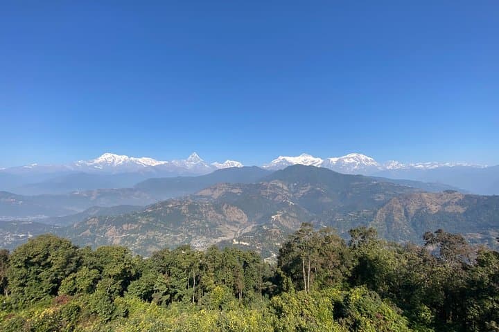
Hiking to Sarangkot is Pokhara’s classic half-day ascent—an honest climb that rewards each switchback with a little more horizon. The route pulls you from the north side of Phewa Lake into cool forest, then threads terraced fields and quiet homes where roosters keep time and prayer flags negotiate with the wind. It’s the kind of trail that asks for steady pacing, a liter or two of water, and a willingness to stop often—not because you’re tired (though you might be), but because the view keeps changing its mind. Annapurna South teases out from cloud. Machhapuchhare, the sacred Fishtail peak, holds its ground like a sentinel, every facet catching light.
You feel the geology beneath your feet. This landscape exists because two continents collided and never stopped pushing—India shouldered into Eurasia and lifted the Himalaya skyward. The hills around Pokhara are the ripples of that long, slow shove. The Seti River gnaws through soft rock just east of the city, carving a gorge so deep and sudden it hides in plain sight. Phewa Lake, second largest in Nepal, is a calm punctuation mark in all that motion. And Sarangkot? It’s a balcony built by tectonics and tended by villagers who’ve shepherded terraced plots for generations.
The cultural story is just as present. This ridge has long been a vantage point for Kaski’s hill communities—Gurung and Magar villages—who farmed these slopes and walked this route long before paragliders discovered the thermals. Today, Sarangkot is also a launch pad for flight, a place where nylon wings listen to morning wind and leap into the valley. The mountain air has opinions; it pushes forward by mid-morning, carrying pilots and dreamers into the same views you hiked to meet on foot.
Most travelers start pre-dawn if they want sunrise, reaching the ridge in about two hours if they move well, a bit longer with photo stops or a tea break. The steps get steeper before the top, then soften as the trail contours along the ridge into the lookout area. Vendors pour sweet milk tea and sell warm momos; the steam carries ginger and garlic into the cool air. As the sun climbs, the range wakes—Annapurna II, III, IV, and the fluted shoulder of Annapurna South take turns catching the first light. Machhapuchhare, revered and unclimbed by tradition, seems to lean forward to listen.
There’s utility in this romance. The terrain is straightforward but sustained: expect 700–900 meters of elevation gain, depending on your exact start point along the lake. The path is a mix of stone stairways, dirt singletrack, and small lane segments through hillside neighborhoods. Grip matters more than speed. In the monsoon months, the forest drips with patience and the stones grow slick; in winter, mornings can run sharp and clear, with frost silvering the grass.
Local pace is the best teacher. You’ll pass schoolchildren climbing faster than you, elders carrying woven dokos up steps with the balance of dancers, and shopkeepers who call out a friendly “Namaste” before returning to cutting vegetables. Many families here supplement farm income with small tea stalls or homestays; a stop for tea is both hospitality and livelihood. Pack your trash out, bring a reusable bottle, and say thank you with your rupees.
For the history-minded, consider that Pokhara once sat along a trade route between India and Tibet. The lakefront now is a travel strip, but in the old bazaar toward the city center you can still find Newari brickwork and carved windows that remember that chapter. Sarangkot itself was a vantage fort in the Kaski principality days, long before Nepal unified. The idea hasn’t changed: this hill is built for watching.
If you have time at the top, wander beyond the main viewpoint to the old village lanes where slate roofs step around courtyards and chickens patrol like security. The ridge keeps unspooling westward, offering quieter nooks where the range feels personal. On a clear day, Dhaulagiri peers over the shoulder from the far west, a giant that refuses to be crowded out.
The descent returns you to the lake, which forgives your knees and invites you to linger. Boats slide by like commas, pausing the conversation. The mountains still loom, but now they feel less like a postcard and more like a neighbor you’ve finally met.
Practicalities: Plan for 4–5 hours round-trip if you start near the north shore of Phewa Lake and spend time at the top. Bring 1.5–2 liters of water, sun protection, and a light layer even in summer—the ridge can catch a breeze that steals heat. No permits are needed for this hike alone, but if you extend into the Annapurna Conservation Area on connecting trails, you’ll need an ACAP permit and TIMS card. Cell service is generally good around villages and on the ridge; it fades in dense forest sections. Best views? Post-monsoon clarity in October and November often delivers the crispest mornings, but winter has a calm, bluebird consistency many travelers love.
Sarangkot doesn’t demand heroics. It asks for attention—to the steps that lead you up, to the people who share this ridge, to the mountains that remake the day every time the light changes. The climb is honest, and the payoff is clean: a balcony in the low Himalaya, built for watching the world wake up.
Trail wisdom
Small choices, better day.
Start Before Sunrise
Begin 60–90 minutes before sunrise to catch first light on Annapurna and avoid mid-morning heat on the stair sections.
Pace the Stairs
Break the ascent into short pushes between landings; breathing remains steady and legs won’t burn out before the ridge.
Hydrate Smart
Carry 1.5–2 liters and refill at village tea houses; use purification tablets if topping up from local taps.
Weather Shifts Fast
Clouds can roll in late morning—check the forecast and aim for early views before the range hides.
Local knowledge
Read the place, not just the route.
Watch for native species including Himalayan bulbul, Grey langur.
Keep an eye out for wildlife during the transition between areas and habitats. Respect distance guidelines.
Stay on established steps to prevent erosion of terraced slopes, and pack out all waste to protect Phewa Lake’s water quality.
Follow the guide's instructions on size limits, ethical handling, and leave-no-trace practices.
Old Sarangkot village lanes west of the main tower for quieter viewpoints. Small tea houses along terrace edges where you can sip chiya away from crowds
Locally recommended viewpoints and quiet spots known best to local operators.
Sarangkot once served as a hilltop watch post for the Kaski principality, and Pokhara sat on a historic trade route between India and Tibet.
Maritime roots and regional tradition shape the waterways and working coasts.
Seasonal guide
Four versions of the same landscape.
Spring
Best forRhododendron blooms · Mild temps
ChallengesAfternoon haze · Intermittent showers
March–May brings fresh greens and flowers with comfortable hiking temperatures; aim for early starts for clearer views.
Summer
Best forLush forest · Quiet trails early
ChallengesMonsoon rain · Slippery stone steps
June–August is wet and humid; carry a rain shell and watch footing on mossy stair sections.
Fall
Best forCrystal views · Stable weather
ChallengesCrowds at sunrise · Strong sun at altitude
September–November offers the clearest skies; start early to beat sunrise rush and bring solid sun protection.
Winter
Best forConsistent blue skies · Cool hiking temps
ChallengesChilly mornings · Occasional frost
December–February is crisp and calm; pack a warm layer and gloves for the ridge before the sun warms the day.
Operator details
What the booking data adds.
Included
- ✓English speaking trekking guide
- ✓Hotel pickup and drop off (within lakeside are pf Pokhara )
- ✓Entrance fee
- ✓Private trip
- ✓Necessary shuttle by private car
Not included
- —Meals and personal expenses
- —Gratitude (Optional)
Good to know
- ✓Not recommended for pregnant travelers
- ✓Suitable for all physical fitness levels
Pack with intention
What to bring.
Good to know
Common questions.
Most hikers complete the round-trip in 4–5 hours from the north shore of Phewa Lake, including breaks and time at the viewpoint.
Plan the edges
The details that make the day easier.
Machhapuchhare (Fishtail) is considered sacred and is officially off-limits to climbing; no one has ever summited it legally.
Post-hike, stroll Baidam Road along Lakeside for thukpa or momos and a ginger tea. If you prefer quiet, cross to the north shore eateries above Phewa Lake’s paddling docks for calmer views. Visit the Old Bazaar later for Newari architecture and spice-scented alleys that hint at Pokhara’s trading past.
- Closest airport
- Pokhara International Airport (PKR). Trailhead: North shore of Phewa Lake, 10–15 minutes from Lakeside by taxi. Distance
- gain
- ~6–9 km round-trip with 700–900 m gain depending on start point. Cell service: Generally good except in dense forest pockets. Permits: Not required for Sarangkot alone; ACAP
Carry a reusable bottle and avoid single-use plastics; stick to established steps to reduce erosion on terraced slopes; support local tea houses and waste initiatives by packing out all trash.
Explore by topic
Follow the threads.
Keep exploring
Make the story part of the trip.
In four hours you can move from shaded canyon ferns to wind-scoured coastal ridgelines, guided by someone who knows where the light—and the hidden views—live. This private half-day hike on the Monterey Peninsula or Big Sur is compact, curated, and perfect for travelers who want depth without a multiday commitment.
 Related story
Beneath a sky of shifting light, Skaftafell’s ice reads like a map of time. This three-hour guided glacier hike mixes technical instruction with geology and culture: compact, safe, and unforgettable.
 Related story
Lose the city for a few hours without leaving it: this 5-mile, 900-foot-gain Forest Park loop threads old-growth pockets, city viewpoints, and cultural landmarks for a compact taste of Portland’s wild side. Expect moss, roots, and stories.