
What the day feels like
First light skimmed the Atlantic as Camps Bay yawned awake, and the Pipe Track unfurled like a quiet promise beneath the buttresses of the Twelve Apostles. The ocean breathed, the mountain listened, and somewhere up the ravine, Kasteelspoort dared you to climb. This is Table Mountain’s western doorway—steep, honest, and rewarding—where the day begins with your shoes scuffing cool sandstone and the scent of fynbos leaning in with its resinous hello.
From Theresa Avenue, the trail finds the Pipe Track in minutes and settles into a warm-up traverse. You can feel the gradient waiting ahead, but the views offer a measured reprieve: Lion’s Head to your shoulder, Camp’s Bay cupped below, a continent’s edge folded into blue. At the Kasteelspoort turn-off, the tone changes. The path steps up, quite literally—stone stairs bite into the slope, switchbacks teeth the ravine, and the Apostles close ranks around you. This is where the mountain tests your morning. It’s never technical, but it is constant, the kind of climb that invites rhythm: short steps, light hands on rock when needed, breath in time with the ocean’s hush.
Along the way, the personality of the Cape Floristic Region shows up in miniature fireworks—king proteas bristling with sunrise, ericas flashing bells and brushes, restios whispering in the breeze. Fynbos is small in stature and epic in diversity, a floral kingdom compressed into fine-grained detail. Keep your eyes tucked to shadows too: the elusive Table Mountain ghost frog lives in these watercourses, a rare local that reminds you every stream here has its own story. The geology underfoot plays the long game—Table Mountain Sandstone, ancient and stubborn, stacking horizontal beds that form ledges, chimneys, and the occasional perfect bench with a view built in.
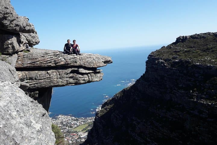
As the ravine eases, the trail tips you onto the Back Table, where the world opens. On calm days, a side path flirts with the old cableway ruins—a skeletal echo of the early 1900s when engineers hauled material up to build the mountain’s reservoirs. Just beyond, the famous "Diving Board" rock juts into empty space, a stone tongue daring brave souls to step out for a photograph. Respect the wind’s mood here; the southeaster can interrogate your balance in a single gust. If it’s howling, let the mountain have the last word and skip the pose.
Most hikers time this as an up-and-back morning—roughly 8–10 km total and 650–800 m of gain depending on side trips. Expect 3.5 to 5 hours at a steady, social pace. The gradients are steep but straightforward, and the trail is well-defined. If you’ve arranged logistics and want a bigger day, you can traverse the flat-topped plateau via the Valley of the Red Gods and Echo Valley to the Upper Cableway, but allow another 1.5–2 hours and verify the cable car is operating before you commit. Across the top, the terrain’s character shifts to boulder gardens and peaty pockets, and fog can arrive like a pulled tablecloth—fast, thick, and absolute.
Kasteelspoort is a favorite for a reason: it’s scenic without being crowded at dawn; it’s a direct line to big views; and it threads you through tangible history. Look for the stone embankments above—the Woodhead and Hely-Hutchinson reservoirs, feats of early engineering that still hold the sky in their mirrored surfaces. The city’s story reads clearly from here: a port pushing outward, a mountain holding firm, communities wrapping around both.
Practically speaking, the route rewards smart preparation. Sunrise starts mitigate heat in summer and catch the mountain at its kindest. Bring 2–3 liters of water; springs are seasonal, and treatment is wise. Grippy trail shoes or lightweight boots matter on the downhike when tired legs meet sandstone steps. A wind layer earns its place year-round. Navigation is intuitive in the ravine but less so on top—have a map app offline and a simple plan: up, explore, back.
Beyond the climb, the experience is a Cape Town microcosm: biodiversity concentrated in a few square kilometers, weather that writes its own script, and a city that feels both far away and touchably close. Dassies sun themselves on warm slabs, sugarbirds whip by with tail streamers like punctuation, and the ocean keeps score of daybreaks. The mountain is not just a backdrop here; it is a neighbor with moods.
If you’re new to Table Mountain, hiking with a local guide adds context and confidence—flora identification in the fynbos maze, safer decision-making around wind and cloud, and a smoother line to the best vantage points. Even for experienced hikers, the mountain’s microclimates command respect. Start early, stay humble with the weather, and let the Apostles set the tempo. On the descent, the city stretches toward lunch and the waterline glints like an invitation. Table Mountain has a way of sending you down both energized and rinsed clean, as if the mountain had nudged you upward just to hand back a sharper version of the day.
What lingers after Kasteelspoort is a sense of proportion. The climb is challenging and accessible, wild and close—an honest handshake with a globally iconic massif. That’s the draw: within a morning, you can touch sandstone older than logic, hear a frog that lives nowhere else, stand where engineers bullied a cable up a cliff, and watch a modern city blink into itself. The past, the present, and your own heartbeat meet in the ravine, then walk out together to breakfast.
Trail wisdom
Small choices, better day.
Beat the heat with a sunrise start
Begin hiking by first light to avoid summer sun on the ravine and catch the best visibility before winds pick up.
Mind the southeaster
Strong winds funnel through Kasteelspoort and the Back Table—skip exposed photo spots like the Diving Board if gusts are present.
Carry enough water
There’s no reliable potable water on route; pack 2–3 liters per person, more in summer.
Navigation gets trickier on top
The ravine is obvious, but the Back Table can be confusing in cloud. Download an offline map and stick to marked paths.
Local knowledge
Read the place, not just the route.
Watch for native species including Rock hyrax (dassie), Cape sugarbird and sunbirds.
Keep an eye out for wildlife during the transition between areas and habitats. Respect distance guidelines.
Fynbos is fragile and slow to recover—stay on established paths, avoid trampling vegetation, and pack out all waste including organics.
Follow the guide's instructions on size limits, ethical handling, and leave-no-trace practices.
Valley of the Red Gods—quiet sandstone corridors just beyond the top of the ravine. Hely-Hutchinson Dam wall—classic reflections on windless mornings
Locally recommended viewpoints and quiet spots known best to local operators.
The ruins near Kasteelspoort are remnants of an early 20th-century construction cableway used to build the mountain’s reservoirs on the Back Table.
Maritime roots and regional tradition shape the waterways and working coasts.
Seasonal guide
Four versions of the same landscape.
Spring
Best forBlooming fynbos · Mild temperatures
ChallengesChangeable wind · Occasional cold fronts
September–November brings fresh greenery, flowering proteas, and comfortable hiking temps with variable breezes.
Summer
Best forClear views · Long daylight
ChallengesHeat exposure · Strong southeaster winds
December–February is hot and often windy—start at dawn, carry extra water, and protect from the sun.
Fall
Best forStable weather · Calmer winds
ChallengesShorter days late season · Cool mornings
March–May is the sweet spot: fewer gales, crisp air, and consistently clear mornings for Kasteelspoort.
Winter
Best forDramatic cloudscapes · Cool hiking temps
ChallengesRain and slick rock · Limited daylight
June–August brings cold fronts and wet trails—pack layers, watch footing, and time your hike between storms.
Operator details
What the booking data adds.
Included
- ✓Small group sizes for a more personal, relaxed, and enjoyable experience
- ✓Registered adventure hiking and culture tourist guide.
- ✓Insights into the area's history, flora, fauna, and local culture
- ✓Tips and recommendations for local restaurants, attractions, beaches, and activities after your hike
- ✓Guidance on responsible hiking practices and Leave No Trace
- ✓Individual attention with hiking pace adjusted to suit the group where possible
- ✓Safety briefing before the hike begins
- ✓Assistance with taking high-quality photos and videos at the best locations
- ✓Regular stops for photos, sightseeing, hydration, and rest
- ✓Basic first aid kit carried by your guide
Not included
- —Cable car ticket one way down
Good to know
- ✓Public transportation options are available nearby
- ✓Not recommended for travelers with spinal injuries
- ✓Not recommended for pregnant travelers
- ✓Not recommended for travelers with poor cardiovascular health
- ✓Travelers should have a high level of physical fitness
- ✓Bring a minimum of 1 liter of water per person
- ✓Have hiking boots or trail shoes
- ✓Have windbreaker
- ✓Have hiking snacks
- ✓Have sunblock
- ✓Guests must have sufficient stamina to hike down if required.
- ✓This hike may not be suitable for those who have undergone knee or hip replacement surgery.
Pack with intention
What to bring.
Good to know
Common questions.
Most hikers complete the up-and-back route in 3.5–5 hours, covering roughly 8–10 km with 650–800 m of elevation gain.
Plan the edges
The details that make the day easier.
Table Mountain was named one of the New7Wonders of Nature in 2011 and anchors the Cape Floristic Region, the smallest yet richest floral kingdom on Earth with over 9,000 plant species—about 70% of which are endemic.
Post-hike, refuel along Camps Bay’s beachfront—grab a flat white and a pastry or settle into a seaside lunch with your boots at your feet. For a local evening, head to Kloof or Bree Street for Cape Malay flavors, fresh seafood, and an easy craft beer crawl. If you have time, visit the Oranjezicht City Farm Market to sample produce from the region and chat with passionate producers.
- Closest airport
- Cape Town International (CPT). Trailhead: Theresa Avenue, Camps Bay via the Pipe Track. Driving time: ~15–25 minutes from the CBD depending on traffic. Cell service: Good on lower slopes, patchy to poor on the Back Table. Permits: None required for this route; observe SANParks rules. Parking: Limited street parking—arrive early and do not leave valuables in vehicles.
This hike crosses sensitive fynbos habitat within Table Mountain National Park—stay on established trails, do not pick flowers, and pack out all trash. Wind can scatter litter; secure wrappers and use reusable bottles.
Explore by topic
Follow the threads.
Keep exploring
Make the story part of the trip.
In four hours you can move from shaded canyon ferns to wind-scoured coastal ridgelines, guided by someone who knows where the light—and the hidden views—live. This private half-day hike on the Monterey Peninsula or Big Sur is compact, curated, and perfect for travelers who want depth without a multiday commitment.
 Related story
Beneath a sky of shifting light, Skaftafell’s ice reads like a map of time. This three-hour guided glacier hike mixes technical instruction with geology and culture: compact, safe, and unforgettable.
 Related story
Lose the city for a few hours without leaving it: this 5-mile, 900-foot-gain Forest Park loop threads old-growth pockets, city viewpoints, and cultural landmarks for a compact taste of Portland’s wild side. Expect moss, roots, and stories.