
What the day feels like
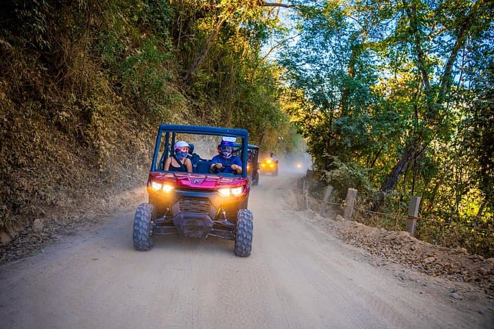
The engine hiccups, then finds a steady growl. Dirt sprays in a fist of sunlit dust behind us as the side-by-side bites into a trail that climbs away from the palm-lined coast. Below, the bay keeps its slow, patient curve; above, the Sierra Madre foothills press in with a jumble of cactus, mango trees and scrub that smells of earth and salt. For three and a half hours you’ll trade the cobblestones of Zona Romántica for switchbacks, river crossings and a view that makes the city — for a moment — feel like someone else’s postcard.
This is not a manicured theme-park ride. The route traced by Side by Side Por La Montaña de Puerto Vallarta is a blur of human and geological history: riverbeds that have been cut and re-cut for millennia, alluvial terraces where small farms cling to the slope, and a coastline that once sustained a scattering of fishermen’s houses before jetsetters and movie stars arrived in the mid-20th century. The off-road trails hug ravines that the River Cuale carved out on the way to Banderas Bay, and the soil here remembers tectonic patience — the Sierra Madre Occidental is a folded spine of volcanic and sedimentary rocks that tilt toward the sea, giving the area abrupt elevation changes and dramatic views.
Puerto Vallarta’s modern identity is as layered as its geology. It was a quiet fishing village until the 1960s, when a certain Hollywood buzz and the filming of The Night of the Iguana helped lift it onto international maps. Today the town is a winning mix of artisan markets, open-air restaurants and a seafront malecón that still pulses with the town’s old-fashioned friendliness. Push inland with a local guide and you’ll see how livelihoods here balance tourism with farming, with small coffee plots, mangos and family orchards tucked into the crevices of the hills.
The practical payoff of a side-by-side tour is immediate. In a single morning you hit terrain that would take a full day on foot: dusty ridgelines, narrow farm roads and a few creek crossings where the river — mischievous and insistent — dares you to keep going. You’ll climb several hundred meters from sea level into more temperate air; the gradient and surface are variable: loose gravel, stone outcrops, rutted stretches and occasional slippery clay after rain. Expect a bumpy, engaging ride rather than a tranquil drive. The vehicles are nimble, but they demand attention: seatbelts fastened, helmets on, and a respect for the limits of both machine and trail.
Why go? The answers are sensory. There are panoramic vistas of Banderas Bay framed by a foreground of bougainvillea and palo santo. There are closer, quieter rewards — a small family-run coffee plot where you can taste a freshly brewed cup on a shaded patio, or a low mirador where the late light turns the ocean slate-blue and the village roofs burn like embers. For photographers, the contrast of jungle and ocean is an addictive palette. For anyone who likes machines and motion, the side-by-side is an honest way to feel the mountain’s geometry without committing to steep trail runs or long climbs.
Preparation is straightforward but meaningful. The tour runs about 3.5 hours (the operator lists a fixed duration of 210 minutes); tide and weather can change how aggressive the trail is, so confirm conditions when you book. The price point starts at about USD 225 per person on the booking page, and many departures advertise free cancellation — a helpful buffer if morning rains come through. Bring closed-toe shoes, a small daypack with water and sunscreen, and a lightweight layer for higher-elevation breezes. If you plan to drive yourself, basic off-road experience is useful; otherwise, sit back and let a guide read the trail.
Safety and etiquette matter as much as the scenery. Keep to the trail to avoid erosion and to protect native plants. If you encounter local farmers, a polite nod goes farther than a photograph without permission. Trash is still the single biggest human footprint here: pack out what you pack in. Guides typically include helmets and basic safety briefings, but double-check inclusions like hotel pickup, bottled water, and whether photos are provided.
When you roll back into town, the contrast is delicious — salt in your hair, dust in the creases of your shirt, and the low hum of the malecón. Spend the afternoon with a limp towel at Playa Los Muertos or cross the small bridge onto the Cuale Island market for handmade jewelry and coffee. A late afternoon cerveza at a beachfront palapa, watching pelicans dive into the bay, is a tidy way to close the day.
This ride is for people who want immediacy: a half-day that trades the curated for the raw, the well-trod for the slightly ragged. It’s not a mountaineering expedition, nor a lazy cruise — it’s a doorway into the hinterlands behind one of Mexico’s most beloved coastal towns. If you go with curiosity, a modest appetite for motion, and a bit of caution, the mountain will oblige with stories, vistas and the kind of small encounters that travel memories are made of.
Trail wisdom
Small choices, better day.
Hydrate before and during
Carry at least 1–2 liters of water per person; the sun and dust dry you out quicker than you expect.
Wear closed-toe shoes
Sturdy sneakers or light hiking shoes protect feet during entry/exit and any short hikes from the vehicle.
Bring a lightweight layer
Temperatures can drop a few degrees as you climb several hundred meters above sea level.
Secure loose items
Use a small daypack or dry bag; phones and cameras can fly in bumpy sections if not stowed.
Local knowledge
Read the place, not just the route.
Watch for native species including Green iguanas, Tropical shore and woodland birds (kingfishers, herons).
Keep an eye out for wildlife during the transition between areas and habitats. Respect distance guidelines.
The Sierra Madre foothills face development pressure; sticking to established trails, avoiding off-trail driving and packing out trash helps protect fragile soils and local flora.
Follow the guide's instructions on size limits, ethical handling, and leave-no-trace practices.
Cuale River Island artisan stalls — a quiet spot for local crafts and coffee. Mirador de la Cruz — a less-visited lookout with sweeping views of the bay
Locally recommended viewpoints and quiet spots known best to local operators.
Puerto Vallarta transformed from a fishing village to an international destination after the 1964 filming of The Night of the Iguana, which drew global attention to the town.
Maritime roots and regional tradition shape the waterways and working coasts.
Seasonal guide
Four versions of the same landscape.
Spring
Best forWildflower blooms · Moderate temperatures
ChallengesOccasional spring showers · Trail softening after rain
Spring offers fresh greenery and mild days; trails can be tacky after rains so confirm conditions before booking.
Summer
Best forLush vegetation · Long daylight hours
ChallengesHotter temperatures · Higher chance of afternoon storms
Summer’s heat and humidity make early departures ideal; expect greener hills and occasional downpours.
Fall
Best forClear skies · Stable conditions
ChallengesResidual summer humidity early in season
Fall is a comfortable shoulder season with good visibility of the bay and fewer crowds.
Winter
Best forDry trails · Best panoramic views
ChallengesCooler mornings at higher elevation
Winter is the dry season—trails are firm and vistas are sharp, making it the most reliable time for off-road outings.
Pack with intention
What to bring.
Good to know
Common questions.
The tour runs approximately 210 minutes (about 3.5 hours) including time for viewpoints and short stops.
Plan the edges
The details that make the day easier.
The filming of The Night of the Iguana in 1964 brought international attention to Puerto Vallarta and helped launch its tourism industry.
After the ride, head to the Cuale Island market for artisanal crafts and fresh coffee, then walk to a beachfront restaurant such as La Palapa or El Arrayán for seafood and a cold cerveza—both spots connect you from mountain dust to coastal cuisine.
- Closest airport
- Gustavo Díaz Ordaz International Airport (PVR). Driving time to downtown Puerto Vallarta: ~20–30 minutes. Typical meeting point: hotel pickup or designated meeting spot in town (confirm with operator). Cell service: reliable in town, patchy on remote stretches. Permits: none typically required—confirm inclusions when booking.
These routes pass through sensitive foothill ecosystems—stay on marked trails, pack out all trash and support locally owned guides and small vendors.
Explore by topic
Follow the threads.
Keep exploring
Make the story part of the trip.
Set out from Bass Harbor for a private, customizable day on Blue Hill Bay — lighthouses, puffins, seals, and the chance to feel Acadia from the water. Small groups, local captains, unforgettable views.
In four hours you can move from shaded canyon ferns to wind-scoured coastal ridgelines, guided by someone who knows where the light—and the hidden views—live. This private half-day hike on the Monterey Peninsula or Big Sur is compact, curated, and perfect for travelers who want depth without a multiday commitment.
 Related story
Beneath a sky of shifting light, Skaftafell’s ice reads like a map of time. This three-hour guided glacier hike mixes technical instruction with geology and culture: compact, safe, and unforgettable.