Three Hidden Alpine Lakes: A Half-Day Hike from Denver
Three glacial tarns, easy elevation, and a fast-to-reach Rockies fix—ideal for half-day adventurers.
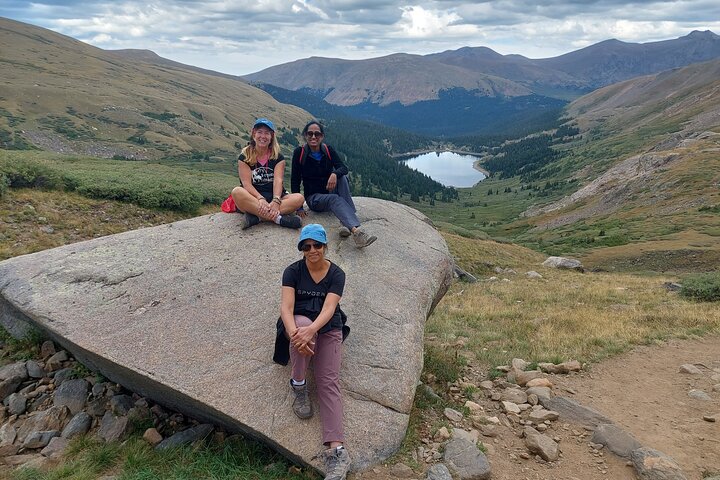
By mid-morning the trail breathes warmth into cold stone. You step through a tunnel of spruce and aspen, sunlight speckling the ground, and the air tastes like pine and rain—clean enough to make you slow your pace and listen. The first tarn appears without fanfare: a glassy bowl cupped in a saddle, reflecting a patchwork of sky and mountain. Keep walking and the trail threads higher, opening to two more bowls—each lake with its own personality: one winkingly small and secretive, one broad and blue, the last edged with talus and a wind that dares you to sit still. This is a half-day in the Colorado Rockies that rewards curiosity more than stamina: three alpine lakes, sapphire and silver, on a route built for discovery. The guided outing advertised from Denver is short on pretension and long on precise, mountainous beauty—ideal if you want alpine clarity without a full-day commitment.
Trail Wisdom
Manage Altitude
Drink extra water before you start and take it slow on the climbs—altitude can make easy distances feel harder.
Layer Smart
Bring a lightweight wind/rain shell and insulating midlayer; mountain weather shifts quickly.
Sun Protection
At elevation UV is stronger—use SPF, sunglasses, and a brimmed hat even on cool days.
Stick to Trail
Stay on singletrack to protect fragile alpine plants and avoid loose talus areas the guide points out.
Local Knowledge
Hidden Gems
- •Higher perch viewpoints just above the third lake for panoramic shots
- •A small creek-side meadow near the lower lake that flowers in early summer
Wildlife
Marmot, Pika
Conservation Note
Stay on marked trails to protect fragile alpine vegetation; pack out all trash and follow Leave No Trace principles in the high-country.
These alpine basins were carved by glacial activity during the last Ice Age and later used seasonally by miners and ranchers before recreation grew.
Seasonal Guide
spring
Best for: Wildflowers, Lower snowline access
Challenges: Late snow patches, Muddy trail sections
Spring brings melting snow and early wildflowers; expect wet sections and possibly lingering snow at higher pitches.
summer
Best for: Clear reflections, Warm mornings
Challenges: Afternoon thunderstorms, Higher visitor numbers
Summer is prime time for stable trail conditions and vivid lake colors—start early to avoid storms and crowds.
fall
Best for: Golden aspens, Crisp air
Challenges: Cold nights, Shorter daylight hours
Fall delivers spectacular aspen color and fewer people, but temperatures drop quickly—dress in layers.
winter
Best for: Snow-covered serenity, Ice photography
Challenges: Snow/ice on trail, Requires snow travel skills
Winter turns the route into a snow landscape suited to experienced winter hikers or snowshoe groups; guided winter trips differ significantly.
Photographer's Notes
What to Bring
Lightweight Hiking BootsEssential
Provide ankle support and grip on rocky upper sections.
1–2L Hydration SystemEssential
Keeps you hydrated in dry mountain air and during exertion.
Wind/Rain ShellEssential
Protects against sudden showers and gusty ridge winds.
Sun Protection (Hat & SPF)Essential
Crucial at elevation where UV intensity is higher.
Common Questions
How hard is the hike for beginners?
This route is moderate: about 4–5 miles round-trip with ~800 feet of gain. Beginners who move steadily and take breaks will find it manageable, especially with a guide.
Do I need experience hiking at altitude?
No prior altitude experience is required, but be aware that exertion feels harder and stay hydrated and paced; guides monitor the group for altitude-related issues.
Are dogs allowed on the guided hike?
Policies vary; most guided group tours do not allow dogs due to group logistics and wildlife protection—check with the operator before booking.
What is included in the tour price?
Guiding fees, local knowledge, and safety briefing are included; confirm with the operator whether transportation from Denver or permits are covered.
Is cell service available on the trail?
Cell service is intermittent to non-existent in higher subalpine zones; expect limited coverage and plan accordingly.
Can the hike be extended into an overnight trip?
Yes—nearby trails connect into backcountry routes suitable for camping with appropriate permits and gear; discuss options with your guide if you want to extend.
What to Pack
Hiking boots (support on rocky trail), 1–2L water (avoid dehydration at altitude), wind/rain shell (sudden weather shifts), sunscreen & hat (high-elevation UV protection)
Did You Know
Many Colorado alpine lakes are glacial tarns carved by ice during the last Ice Age—these small basins often support unique, fragile alpine ecosystems.
Quick Travel Tips
Start early to avoid afternoon storms; dress in layers; carry extra water; book early—trips can sell out on summer weekends.
Local Flavor
After the hike, head back toward Denver or stop in the foothills towns—Golden and Boulder have excellent post-hike options: try Mountain Sun Brewery in Boulder for a local beer and comfort food, or Golden’s Sherpa House for hearty mountain fare.
Logistics Snapshot
Closest airport / trailhead: Denver International Airport (DEN) to trailhead ~45–75 minutes by car depending on route; Driving distance: roughly 40–60 miles from Denver city center; Cell service: intermittent in subalpine zones; Permits/passes: none for day hikes generally, but check local trailhead parking rules.
Sustainability Note
This area relies on healthy alpine ecosystems—pack out all waste, keep group sizes moderate, and avoid trampling lakeshore vegetation to protect sensitive habitats.