
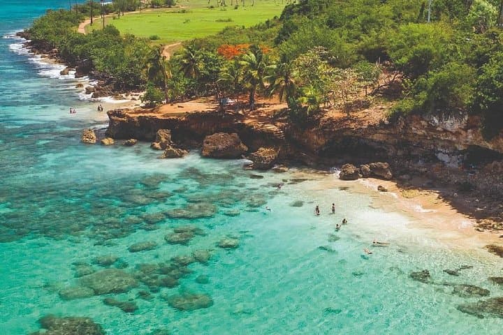
What the day feels like
By midmorning the water has already warmed to a comfortable clarity—green-blue close to shore, deepening to indigo where the reef drops away. You stand at the lip of Aguadilla’s beach, mask fogged from the humid air, and the ocean seems to dare you forward: come see what lives beneath. The guide fits your snorkel, points to a swath of life-packed coral, and then the day unfurls with a simple efficiency that feels almost criminal: snorkeling, waterfalls, roadside food, and a short hike to a cliffside cave with Taíno petroglyphs—each stop a different mood of Puerto Rico’s north shore.
This is not a leisurely beach day stretched into evening; it’s a tightly choreographed, one-day slice of the island’s varied topography. In roughly 9.5 hours (the tour runs about 570 minutes), you move from the sandy, surf-churned edges of Aguadilla to the soft plunge pools of Gozalandia and finish at Cueva del Indio, where the cliffs explain themselves in stone and spray. The transitions are part of the thrill—the shift in temperature, the skin’s dampness, the smell of frying plantains that signals the lunch stop.
Geologically, this coastline is a conversation between limestone and sea. The northern rim of Puerto Rico is carved from Miocene-era carbonates and uplifted terraces, creating pockets where caves and cliffs capture the ocean’s appetite for drama. Cueva del Indio is a textbook example: wave-polished hollows and a gallery of petroglyphs left by the Taíno people, small in scale but enormous in cultural resonance. Inland, Gozalandia claims a different language—streams cut through fertile soil and gather into plunge pools that invite toe-testing, then cannonballing.
Culturally, a day like this threads together contemporary Puerto Rican life and older layers. Roadside kiosks serve mofongo and fresh ceviche; the guide will point out the telltale tile roof of a sugar-era hacienda or name a hill that once kept watch. These aren’t museum placards—this is lived place, where traditions meet tourism on practical terms. Expect friendly, direct hospitality: the island’s particular mix of Spanish, African, and Taíno influences shows up in food and gait, in the way locals give directions, and in the patience of someone who knows tides on the north shore.
Where the narrative becomes practical: the snorkeling at Aguadilla is best in calm conditions—reef, clear water, and warm temps generally between 78–82°F (25–28°C). Gozalandia’s falls involve a short walk from the parking area and a descent to the pools that can be slippery; comfortable water shoes matter. The hike to Cueva del Indio is less about elevation gain and more about footing—the trail uses a mix of packed dirt and coastal rock and ends where the cliffs let you look over Atlantic swell that can be both mesmerizing and suddenly dangerous. Guides on this tour will time the stops for safety and photo opportunities, and they typically include basic snorkeling gear, water, transportation between sites, and photography services so you can leave your phone safe in the van.
Safety is specific here: avoid touching coral or hauling yourself over a reef during low tide; watch the surf at Cueva del Indio—the rocks can be slick and rogue waves do come in. At Gozalandia, don’t jump from uninspected heights; the guide will point out recommended plunge spots. Hydration and sun protection are not optional: reef-safe sunscreen, a wide-brim hat, and frequent water breaks will keep you feeling good. Footwear should double as water shoes—think quick-drain soles with toe protection. Finally, if you want to eat like a local, skip the tourist strip and ask your guide for recommendations; expect fresh seafood and fritters at a modest price.
Why would a traveler book this? In a single, well-paced day you get three distinct ecosystems—beach reef, freshwater falls, and coastal cave—each with a different physical rhythm. For travelers short on time, this tour is a compressed primer on Puerto Rico’s natural and cultural range. For more experienced adventurers, the appeal is the way the tour stitches access and local insight into places that otherwise require independent transport, logistics, and local knowledge to reach safely and meaningfully.
Practical snapshot: plan for a long day—start early, wear layers you can strip, bring a small dry bag for electronics, and be ready for frequent photo stops. If you’re snorkeling for the first time, let the guide show you the basics; if you’re a seasoned snorkeler, bring a mask with a good fit. And remember the conservation subtext: these places are busy and fragile. Leave nothing behind, be mindful of coral and tide pools, and use reef-safe products.
At the end of the day you’ll have salt in your hair, a few good photos, and the sense that the island’s north coast is a series of conversations—between land and sea, between past and present, between a cuisine grown in small kitchens and the open Atlantic. It’s a lot to fit into one day. That’s the point.
Tour details: roughly 9.5 hours, includes transportation and guide, photo service included, price starts from about $134 (subject to seasonal offers). This is a solid option for travelers who want to compress Puerto Rico’s coastal variety into a practical, exhilarating day.
Trail wisdom
Small choices, better day.
Start Early
Morning light calms the water for better snorkeling visibility and cooler hiking conditions at Gozalandia and Cueva del Indio.
Wear Water Shoes
Trails and rocky shorelines are slippery—closed-toe, quick-dry shoes protect feet and improve traction.
Use Reef-Safe Sunscreen
Protect both your skin and the coral—apply before you hit the water and reapply after swimming.
Secure Valuables
Bring a small dry bag for phones and wallets; the tour typically offers photography services so you can leave electronics stashed.
Local knowledge
Read the place, not just the route.
Watch for native species including Brown Pelican, Green Sea Turtle (occasionally seen near reefs).
Keep an eye out for wildlife during the transition between areas and habitats. Respect distance guidelines.
Use reef-safe sunscreen, avoid standing on coral, and pack out all trash—the north shore’s reefs and freshwater systems are sensitive to human impact.
Follow the guide's instructions on size limits, ethical handling, and leave-no-trace practices.
Crash Boat Beach (Aguadilla) for easy shore snorkeling and colorful boats. The upper tier of Gozalandia Falls for quieter pools away from the main cliff-jump area
Locally recommended viewpoints and quiet spots known best to local operators.
Cueva del Indio contains Taíno petroglyphs and sits on a coastline long used for fishing and lookout points during Spanish colonial times.
Maritime roots and regional tradition shape the waterways and working coasts.
Seasonal guide
Four versions of the same landscape.
Spring
Best forClear snorkel conditions · Warmer inland hikes · Lower chance of heavy rain
ChallengesOccasional showers · Busy spring break crowds
Spring (March–May) offers stable visibility for snorkeling and comfortable hiking temps—expect more visitors near popular falls.
Summer
Best forWarmest water temperatures · Longer daylight for photos · Lush inland foliage
ChallengesAfternoon thunderstorms · Higher humidity and heat
Summer brings hot, humid conditions and more frequent short storms—start early to avoid afternoon rain.
Fall
Best forFewer crowds after summer · Good sea conditions early in season · Rich post-rainfall greenery
ChallengesHurricane-season risk (Aug–Nov) · Potential for rough seas
Fall can be rewarding but carries hurricane-season uncertainty—watch forecasts and booking protections.
Winter
Best forDriest weather (Dec–Feb) · Cooler, comfortable hiking · Calmer seas on many days
ChallengesSlightly cooler water temps · Higher visitor numbers over holidays
Winter is Puerto Rico’s dry season and often the most predictable for clear water and stable conditions.
Operator details
What the booking data adds.
Included
- ✓Visit to Aguadilla City
- ✓Private Transportation
- ✓Visit to Gozalandia Falls
- ✓Snorkeling
- ✓Visit to the Natural Reserve of Cueva del Indio
Not included
- —Prices of dishes and beverages are not included
Good to know
- ✓Service animals allowed
- ✓Public transportation options are available nearby
- ✓Infants are required to sit on an adult’s lap
- ✓Not recommended for pregnant travelers
- ✓Not recommended for travelers with poor cardiovascular health
- ✓Travelers should have at least a moderate level of physical fitness
Pack with intention
What to bring.
Good to know
Common questions.
The tour typically includes basic snorkeling gear, but if you have a well-fitting mask and fins you prefer, bring them for comfort.
Plan the edges
The details that make the day easier.
Cueva del Indio features Taíno petroglyphs—rock carvings left by the indigenous people that lived on the island before European contact.
After the adventure, look for a small eatery serving mofongo or fresh ceviche near Aguadilla’s beaches—pair a cold Medalla beer with fried plantain fritters and ask locals about their favorite beach for sunset.
- Closest airport
- Rafael Hernández Airport (BQN) in Aguadilla; Driving from Aguadilla to Gozalandia ~45–60 minutes; Cell service: generally good near towns, spotty on remote cliffs; Permits: none required for day visits, but follow local rules at parks and private entrances.
This tour visits fragile marine and freshwater sites—use reef-safe products, stay on marked paths, and pack out all trash to minimize impact.
Explore by topic
Follow the threads.
Keep exploring
Make the story part of the trip.
In four hours you can move from shaded canyon ferns to wind-scoured coastal ridgelines, guided by someone who knows where the light—and the hidden views—live. This private half-day hike on the Monterey Peninsula or Big Sur is compact, curated, and perfect for travelers who want depth without a multiday commitment.
 Related story
Beneath a sky of shifting light, Skaftafell’s ice reads like a map of time. This three-hour guided glacier hike mixes technical instruction with geology and culture: compact, safe, and unforgettable.
 Related story
Lose the city for a few hours without leaving it: this 5-mile, 900-foot-gain Forest Park loop threads old-growth pockets, city viewpoints, and cultural landmarks for a compact taste of Portland’s wild side. Expect moss, roots, and stories.