
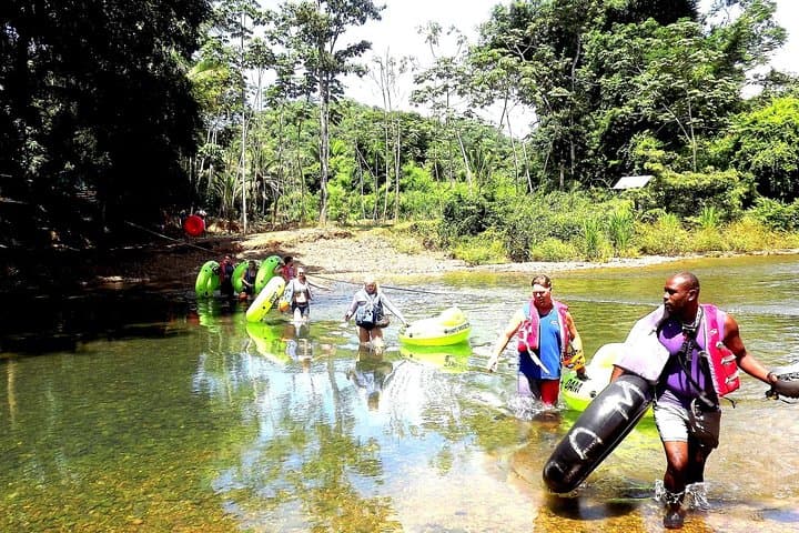
What the day feels like
The river doesn’t sneak up on you; it invites. By mid-morning the Caves Branch and Mopan slow their hurry into a velvet current that catches the sun and threads light through sugar-leaf canopy. When your guide slips a crushable tube into the water and pats the rim like a good-bye, it feels less like an exit and more like permission—permission to let the river steer the day, to float through passages shaped by limestone and time, and then climb into a different kind of history at Xunantunich, one of Belize’s most atmospheric Maya sites. This shore excursion stitches water and stone together: cave tubing where the earth lifts its roof into cathedrals of calcite, then a short drive to the plateau where El Castillo pins a city of plazas and stelae against the sky.
The geology here is honest and blunt: the Cayo District sits on limestone bedrock that dissolved over eons, creating caverns that now hold slow rivers and fossilized speleothems. Those dripstones—stalactites and stalagmites—are more than ornaments; they’re calendars of water and mineral, slow sculptures that record wet seasons and droughts. Guides will point out flowstone curtains and scalloped cave walls that read like topography in miniature. Above ground, the Mopan River and the valley below Xunantunich reveal a landscape sculpted by the same chemistry—karst ridges, sinkholes and fertile alluvial flats where the Maya once planted manioc and maize.
Xunantunich itself is a study in scale and ritual. The site’s principal temple, El Castillo, pierces the forest canopy and was a civic and ceremonial anchor for the region’s Maya population centuries ago. From the summit you can feel why the spot mattered: the river snakes below, the Belizean lowlands stretch distant and, on clear days, the silhouette of Guatemala’s hills is visible on the horizon. Local guides bring the stones to life—interpreting carved faces, describing how plazas were stages for politics and religion, and pointing out the weathered stucco masks that once flashed color in the sun.
Culturally, the route between river and ruin is a local story. The guides you meet are frequently from nearby communities, descendants of Maya families who still speak Mopan or Kekchi Maya and who steward the landscape as both home and heritage. The tour’s private format means the pace is yours, with chances to ask questions about agricultural practices, local folklore—like the lady in white (Xunantunich’s namesake myth)—and how modern Belizeans balance tourism with daily life.
Practically speaking, this is a day that asks for sensible preparation more than high-performance kit. The tubing section is mellow—designed for cruisers and mixed groups—so flotation is steady and guides lead the way. Still, bring a sturdy pair of sandals or neoprene booties, a small dry bag for your phone and sunscreen that’s reef-safe. Expect a full day: transport from Belize City or the cruise port takes most of the morning, the cave section runs an hour or two depending on how often you stop, and Xunantunich deserves at least 60–90 minutes on the ground to appreciate architecture and viewscapes.
Safety is practical: guides provide life vests and helmets in cave sections where low ceilings and slick steps appear. If you’re prone to claustrophobia, talk to your guide ahead of time—routes through the karst system favor airy chambers over tight squeezes on this excursion. Also be realistic about fitness. The hike at Xunantunich includes stone stairways and packed-earth paths; the climb to El Castillo’s summit is a steep, exposed set of steps that rewards caution and steady breathing.
Timing matters. Belize’s dry season (roughly late November to April) produces clearer cave passages, lower water turbidity and cooler mornings that make river time pleasant. Afternoon storms in the wet season can swell rivers and make driving slower; they also transform the jungle into a lush, insect-rich theater—beautiful but wetter. For photography, morning light in the plazas and late-afternoon glow on the river create two different palettes: sharp, graphic temple shots at noon and softer, contrast-rich scenes as the sun drops.
This is also an opportunity to travel lightly and thoughtfully. Park fees support site maintenance at Xunantunich; tipping guides and drivers sustains small local operators. Much of the value of the day comes from interpretation—your guide’s stories, local knowledge of flora and fauna, and the shared rhythm of river and stone—so investing in a knowledgeable, respectful tour operator benefits both you and the places you visit.
When the day winds down—tubes stacked, boots rinsed, cameras off—the memory isn’t only of the temple silhouette or the cold of cave water. It’s of the way the landscape holds time: a river that remembers where it carved itself, caves that keep the pulse of centuries, and a stone city that still offers its terraces to visitors. A single day like this lets you float between two tempos—the patient, geological pulse and the sharp human one—and that contrast is the trip’s quiet reward.
Trail wisdom
Small choices, better day.
Mind the Sun
Apply reef-safe sunscreen before you start and reapply after tubing—shade is limited at Xunantunich’s summit.
Bring a Dry Bag
A small dry bag keeps your phone, wallet, and camera protected when you drift; many guides have lockers but bring one just in case.
Sturdy Footwear
Wear sandals with straps or light trail shoes for slick cave edges and stone steps at the ruins.
Hydrate and Snack
Carry a reusable water bottle and energy snacks—there are breaks but shops are limited between sites.
Local knowledge
Read the place, not just the route.
Watch for native species including Howler monkey, Tropical kingfisher.
Keep an eye out for wildlife during the transition between areas and habitats. Respect distance guidelines.
Park fees and local guide permits fund preservation work; visitors are asked to stay on designated trails, avoid touching fragile stucco, and carry out all trash.
Follow the guide's instructions on size limits, ethical handling, and leave-no-trace practices.
Stop at the San Ignacio Market for fresh tropical fruit and local snacks after the tour. Ask your guide about lesser-known petroglyphs and vista points near Xunantunich for quieter photos
Locally recommended viewpoints and quiet spots known best to local operators.
Xunantunich was a regional Maya center during the Late Classic period; its name—meaning 'Stone Woman'—comes from local folklore tied to a ghostly figure said to appear at the site.
Maritime roots and regional tradition shape the waterways and working coasts.
Seasonal guide
Four versions of the same landscape.
Spring
Best forDry trails and clear photos · Comfortable river temperatures
ChallengesHigher cruise-ship visitor numbers · Midday sun can be strong
Spring (Feb–Apr) offers the most predictable weather for caving and clear views from El Castillo, though popular days can be busy.
Summer
Best forLush jungle scenery · Warmer water for tubing
ChallengesAfternoon storms and higher humidity · Possible road slowdowns
Summer makes the forest intensely green and the river warm, but plan for sudden downpours and flexible timing.
Fall
Best forFewer crowds after high season · Comfortable temperatures
ChallengesResidual wet-season conditions early in fall · Variable river clarity
Fall balances shoulder-season calm with the tail end of wetter conditions—good for travelers who want fewer people.
Winter
Best forCooler mornings for hiking · Drier caves and better visibility
ChallengesCooler water temperatures · Potential higher demand from holiday travel
Winter (Dec–Feb) delivers crisp mornings and clear caves, though the water can feel cold coming out of shaded passages.
Operator details
What the booking data adds.
Included
- ✓Local Belizean Dish (Rice & Beans with Stew Chicken)
- ✓Air-conditioned vehicle
- ✓Helmet, Lights and Tube
- ✓Entrance Fee Into Park
Good to know
- ✓Public transportation options are available nearby
- ✓Not recommended for travelers with spinal injuries
- ✓Not recommended for travelers with poor cardiovascular health
- ✓Suitable for all physical fitness levels
Pack with intention
What to bring.
Good to know
Common questions.
Typical tubing time on this shore excursion is about 45–90 minutes, depending on how often the group stops for photos and interpretation.
Plan the edges
The details that make the day easier.
El Castillo at Xunantunich rises roughly 40 meters (about 130 feet) above the plaza, making it one of Belize’s tallest ancient structures and offering sweeping views across the Mopan valley.
After the day’s river and ruins, head to San Ignacio for plates of stewed chicken and rice at a local comedor or sample regional favorites at Guava Limb Café; wash down the meal with an ice-cold Belikin and catch live music at a small town bar to hear contemporary Belizean rhythms.
- Closest international airport
- Philip S. W. Goldson International Airport (BZE); Driving time from Belize City port to Xunantunich area: 1.5–2 hours each way (shore-excursion drivers manage timing); Cell service: intermittent outside towns; Permits
- Fees
- park entry fees apply at Xunantunich—payable on-site; Tour duration: full-day shore excursion, expect 6–8 hours
This route passes sensitive karst and archaeological zones—respect site boundaries, avoid touching stucco and dripstone formations, and support local guides whose training and permits fund conservation.
Explore by topic
Follow the threads.
Keep exploring
Make the story part of the trip.
 Related story
Less than two hours from Nairobi, Kereita Forest pairs hands-on canopy adventure with quiet montane trails and a sobering colonial history—perfect for families, teams, and curious travelers seeking a full-day pulse of nature.
Set out from Bass Harbor for a private, customizable day on Blue Hill Bay — lighthouses, puffins, seals, and the chance to feel Acadia from the water. Small groups, local captains, unforgettable views.
In four hours you can move from shaded canyon ferns to wind-scoured coastal ridgelines, guided by someone who knows where the light—and the hidden views—live. This private half-day hike on the Monterey Peninsula or Big Sur is compact, curated, and perfect for travelers who want depth without a multiday commitment.