
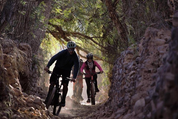
What the day feels like
Morning breaks over Tilcara with a clean, high-altitude light that wastes no time. The Andes do not ease into the day; they rise and hold their ground, ribbed with ochre, emerald, and rust. A breeze slides down the Quebrada de Humahuaca and nudges your front tire, as if to say: let’s see what you’ve got. The Río Grande keeps you company to the west, a quiet ribbon this time of year, its dry-season current whispering toward Jujuy. You clip in, roll away from the adobe streets, and the town recedes to a smudge of color, music still humming from last night’s peñas beside the main square. Here, the valley opens its arms—wide, serious, and full of story.
On a guided ride around Tilcara, it’s the terrain that tells the plot. A hard-packed track leads out along the valley floor, rippled with old washboard and dusted in red powder that clings to your calves. Ahead, the hills stack like folded blankets: green from mineral-rich clays, pink from iron, pale yellows and creams from limestone. The mountains here like to show their stripes, and they do it without apology. You move through a thousand colors in a few kilometers, feeling the altitude (roughly 2,460 meters/8,070 feet) in your chest while the wind urges you onward.
A common loop threads through farm plots and terraces—places where quinoa, maize, and beans have been coaxed from thin soils since long before the Spanish arrived. The path narrows in places, a soft singletrack bordering the riverbed, then widens to gravel lanes that lead toward the Pucará de Tilcara. This pre-Inca fortress, restored in parts, stands on a rocky promontory as if keeping watch. Its stone walls don’t just mark a site; they mark continuity, a reminder that this valley has been a thoroughfare for trade and culture for millennia. If you pause here, you can almost feel the ground storing heat beneath the tires, the fortress shouldering the wind as it has for centuries.
Guides in Tilcara, many born and raised in the Quebrada, know how to stitch scenery to context. They’ll point across the valley to goat trails that cut toward the Garganta del Diablo, a narrow canyon that swallows light and amplifies the sound of water. They’ll explain how this long corridor—the Quebrada de Humahuaca—was once a vital segment of the Andean road networks, later folded into the Incan Qhapaq Ñan. In 2003, UNESCO recognized the Quebrada as a World Heritage site for its cultural route and living traditions. You feel that living part when a shepherd steps aside with a nod, dogs in tow, or when the scent of woodsmoke drifts from a tiny roadside parrilla where lunch will later be a plate of llama empanadas, a squeeze of lemon, and a cold beer.
The geology is a patient teacher. Each pedal stroke over gravel hints at the valley’s construction: erosion carving sediment from the high puna, rivers rearranging it into the layered palette that makes the Quebrada famous. In summer, storms muscle down these slopes, the Río Grande flexing with sudden force. In winter, the air sharpens and skies stay clean, the sun pacing the ridgelines like a metronome. Today, in the dry season, the trail is quick and honest—loose over hardpack, the corners asking for respect. Your bike hums. The tires bite. The valley’s breath is dry and direct, and it keeps you honest too.
It’s an approachable ride by Andean standards. Most guided outings here run roughly 8–15 kilometers with short, punchy climbs and rolling terrain. The biggest factor is altitude. Even if you consider yourself fit, the thin air asks you to find a lower gear, to sit, to spin, to let the cadence settle the nerves. The payoff is steady: open horizons, condors riding thermals over the ridges, adobe hamlets tucked into hillsides, and that feeling of being a small moving piece inside a large, confident landscape.
What stands out here is texture—of land and life. Tires thrum on ancient cobbles near the edge of town, then float through sandy wash. You pass hand-painted signs for workshops selling ceramics baked in backyard kilns. If you stop to refill water, someone might ask where you’re from, offering directions with a useful wave of the hand and a smile. The Quebrada doesn’t perform for visitors; it carries on. You simply step into its rhythm for a couple of hours.
Practicalities make this ride enjoyable rather than taxing. Plan for intense sun and reflective light off pale soils; a brimmed cap under the helmet and a high-SPF sunscreen are smart. Closed-toe trail shoes with a bit of tread handle the occasional hike-a-bike. Bring at least a liter of water—more if it’s summer—and consider a light wind shell for the afternoon breeze that slips down-canyon. Expect a mix of surfaces: gravel, compact dirt, some rocky bits, maybe a shallow sand stretch near the river. A guide will keep you on the best lines and tailor the pace; communication is straightforward and the atmosphere welcoming.
Post-ride, the square in Tilcara calls. Empanadas and humitas steamed in corn husks. A glass of torrontés if you’re lingering, or a lemonade bright with Andean citrus if you’re still thirsty from the dry air. You can walk through the market where woven textiles hang like flags and ceramic guardians peer from shelves. If there’s energy left in the legs, pair the pedal with a short walk to the Pucará, letting stonework and cactus gardens round out the day’s story.
The Quebrada de Humahuaca invites many forms of travel—on foot, by car, on horseback—but a bike finds a sweet spot. You move fast enough to see distance change and slow enough to hear the valley speak. The river nudges your route. The wind sets the tempo. The mountains, painted by time, let you pass and then watch you go, knowing you’ll remember their colors long after the dust shakes from your shoes.
Trail wisdom
Small choices, better day.
Acclimate before you ride
Spend a day in Tilcara (2,460 m/8,070 ft) before biking to adjust to altitude and avoid headaches or shortness of breath.
Dress for sun and wind
UV is intense year-round; wear sunscreen, sunglasses, and pack a light wind shell for afternoon gusts in the valley.
Expect mixed surfaces
The route blends compact dirt, gravel, and short sandy sections—ride with relaxed arms, look ahead, and feather brakes on loose corners.
Hydrate smart
Bring at least 1–1.5 liters of water per person; the dry climate and altitude dehydrate faster than you think.
Local knowledge
Read the place, not just the route.
Watch for native species including Andean condor, Burrowing owl.
Keep an eye out for wildlife during the transition between areas and habitats. Respect distance guidelines.
Stay on established tracks to prevent erosion on fragile slopes, and avoid riding across archaeological terraces. Pack out all trash and refill water to reduce single-use plastic.
Follow the guide's instructions on size limits, ethical handling, and leave-no-trace practices.
A detour toward the Garganta del Diablo road for canyon views without the crowds. Small ceramic workshops east of the plaza where artisans fire traditional pieces
Locally recommended viewpoints and quiet spots known best to local operators.
The Quebrada de Humahuaca is a UNESCO World Heritage site (2003) for its role as a cultural route, with the Pucará de Tilcara showcasing pre-Inca fortifications and terrace agriculture.
Maritime roots and regional tradition shape the waterways and working coasts.
Seasonal guide
Four versions of the same landscape.
Spring
Best forCrisp mornings · Wildflower accents
ChallengesVariable winds · Cool starts
September–November brings clear light, mild temps, and firm track conditions—great for balanced riding and scenic views.
Summer
Best forLong daylight · Lush canyon walls
ChallengesAfternoon storms · Muddy patches and higher river flow
December–February is the rainy season; expect powerful sun between showers, slick sections, and the possibility of trip adjustments for safety.
Fall
Best forStable weather · Low crowds
ChallengesCool evenings · Dust on popular tracks
March–May offers some of the best riding—dry, sunny days and cooler temps that favor steady pedaling at altitude.
Winter
Best forBluebird skies · Firm trails
ChallengesChilly mornings · Strong midday UV
June–August is dry and sunny; start rides later in the morning to avoid the cold and layer for changing temps.
Operator details
What the booking data adds.
Included
- ✓bicycle, helmet
- ✓Bottled water
Good to know
- ✓Not recommended for travelers with spinal injuries
- ✓Not recommended for pregnant travelers
- ✓Not recommended for travelers with poor cardiovascular health
- ✓Suitable for all physical fitness levels
Pack with intention
What to bring.
Good to know
Common questions.
Most guided outings around Tilcara cover 8–15 km with rolling terrain and short climbs. It’s moderate overall, with altitude being the main challenge.
Plan the edges
The details that make the day easier.
The Quebrada de Humahuaca was inscribed as a UNESCO World Heritage site in 2003 for its 10,000-year history as a cultural route connecting Andean societies.
Recharge on the plaza with humitas and tamales, or try llama empanadas and a local craft beer along Belgrano Street. In the evening, catch live folk music at a peña and sip coca tea—a traditional antidote to altitude—before wandering the artisan market for textiles and ceramics.
- Closest airport
- Gobernador Horacio Guzmán International (JUJ), ~112 km south. Trailhead: Typically departs near central Tilcara. Drive time: ~2 hours from JUJ; ~3.5–4 hours from Salta (SLA). Cell service: Reliable in town, patchy in the canyons. Permits: None for biking; separate ticket for Pucará de Tilcara.
This valley’s soils are fragile and easily eroded—ride only on existing tracks, avoid wet trails after summer storms, and respect archaeological sites. Refill bottles at your lodging or cafes to minimize plastic waste and support local businesses.
Explore by topic
Follow the threads.
Keep exploring
Make the story part of the trip.
Set out from Bass Harbor for a private, customizable day on Blue Hill Bay — lighthouses, puffins, seals, and the chance to feel Acadia from the water. Small groups, local captains, unforgettable views.
In four hours you can move from shaded canyon ferns to wind-scoured coastal ridgelines, guided by someone who knows where the light—and the hidden views—live. This private half-day hike on the Monterey Peninsula or Big Sur is compact, curated, and perfect for travelers who want depth without a multiday commitment.
 Related story
Beneath a sky of shifting light, Skaftafell’s ice reads like a map of time. This three-hour guided glacier hike mixes technical instruction with geology and culture: compact, safe, and unforgettable.