
What the day feels like
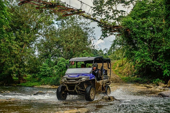
The engine settles into a low, insistent growl and the trail ahead narrows into nothing more than tire-scored ribbon through green. Rainforest fronds lean in, as if to listen; a river ahead chuckles and dares you to cross. You feel the machine respond beneath you—stiff, predictable, eager—and for the next two hours the landscape around La Fortuna will not be a postcard but a living thing: muddled, loud, and intimate. This is not a sanitized amusement; it’s a private-estate run through working farmland, forest, and riverbeds where the land still keeps a few sharp edges.
A side-by-side ride around Arenal is equal parts practical transport and a theatrical way to read the landscape. The two-hour loop, led by a local guide, threads farm tracks, climbable ridgelines, and low-water crossings. Expect roughly 10–25 kilometers (6–15 miles) of trail in that time, with short climbs that net about 300–900 feet (100–300 meters) of cumulative elevation change—enough to open views of the low hilltops and, on a clear day, the cone of Arenal itself. Trails range from packed dirt to rocky ruts and the occasional clay bog that will test your tires and your nerves. You pause often—at a river bend where the guide sheds a story about the property, at a field of grazing cows, at a streambank where leaf litter smells like wet coffee—and those stops stitch the ride into a narrative about rural Costa Rica.
The Arenal region's story is geological as much as cultural. The volcano that dominates the horizon until 2010 reworked soils, redirected rivers, and fed the hot springs that have become a lifeline for tourism. The land here remembers those eruptions: thick volcanic soils hold moisture and feed the dense vegetation; small ridgelines are capped with older lava flows. The private estates that allow these rides are a patchwork of cattle plots, banana stands, and forest reserves. On your route you’ll pass functioning farm buildings—corrals, machinery, trails cut for hauling—evidence that this is not a curated set piece but a working landscape.
Culturally, what you’re seeing is part of the larger rural economy around La Fortuna. Farmers rotate pastures, tend small plots of plantains and pineapple, and rely on the rainfall rhythms that also make the area intensely green. Your guide is a storyteller and a practical translator of place: they’ll explain how water is diverted for crops, where the best mango tree stands, and how local families historically used the forest for building materials. There’s a humility to it—this land gives and takes—and the ride gives visitors a grounded view of life beyond the resort strip.
After the scenic and sometimes technical stretches, the tour usually eases into the most social part: a stop by the river. Guides pause here to let riders step out, cool off, and watch the current rearrange stones. The water is not a backdrop; it insists on being noticed—the flow nudges branches, reflects sunlight like a wink, and in its way invites you to sit and be small.
Practicalities matter. This is a two-hour experience that moves fast enough to keep the adrenaline up but slow enough to let you take photos and ask questions. Vehicles are stable but off-road terrain demands attention: closed-toe shoes, a light layering system for quick sun-to-shade changes, and a small daypack with water will keep you comfortable. Guides are usually local people with deep knowledge of the property; they manage river crossings and will brief riders on steering, braking, and passenger etiquette.
Why do this instead of a walking hike or a canopy tour? The side-by-side compresses a lot of Arenal’s varied environments into a compact, accessible window. You’ll see forest edge, agricultural systems, sediment-lined rivers, and the human work that knits them together, all from a perspective that lets you go farther than a footpath and slower than a highway. It’s excellent for travelers who want a dose of nature without committing to a long trek—or who want to add a tactile, muddy chapter to a trip otherwise spent on hot springs and waterfalls.
Safety and sustainability are part of the package. Respect private property, listen to the guide’s instructions on crossing rivers, and remember that off-road machines can stress soil and wildlife if misused. A responsible operator limits the number of vehicles on the estate, sticks to existing tracks, and encourages riders not to feed wildlife or disturb farm operations.
If you go: time your ride in the morning for cooler air and softer light, bring a waterproof shell in the green season, and keep your camera secure—there will be moments you want to keep but can’t risk dropping. When the tour winds back toward the estate and the engine falls quiet, you’ll realize the afternoon has left a different kind of residue than a postcard: the smell of diesel and wet earth, a few specks of mud on your boots, and a clearer picture of how the La Fortuna hinterland functions.
This side-by-side loop is not just about speed or thrills. It’s a short, efficient education in terrain and people, a two-hour argument made in dirt and water for why Arenal is more than a volcano. It’s a ride you remember for small textures—the click of gates, the way a farmer waves from a distance, the river’s patient insistence that life here keeps moving. And when you step off, you’ll be ready to eat something local, take a hot-spring soak, and tell the story with details that matter.
Trail wisdom
Small choices, better day.
Keep Hydrated
Bring at least 1 liter of water per person; the humid heat and adrenaline make you sweat more than you expect.
Wear Closed-Toe Shoes
Sturdy trail shoes or light hiking boots protect toes from rocks, mud, and footwells on the side-by-side.
Secure Your Phone
Use a wrist strap or chest harness for cameras and phones—river crossings and sudden bumps will test your grip.
Listen to Your Guide
Follow instructions for passenger positioning and braking during river crossings; guides know the safest lines.
Local knowledge
Read the place, not just the route.
Watch for native species including White-faced capuchin monkeys, Keel-billed toucans (occasional).
Keep an eye out for wildlife during the transition between areas and habitats. Respect distance guidelines.
Responsible operators stick to existing tracks to limit erosion and avoid sensitive forest patches; visitors should avoid littering and respect farm operations.
Follow the guide's instructions on size limits, ethical handling, and leave-no-trace practices.
A quiet riverbank upstream where local families picnic (ask your guide for access). A small roadside soda (local diner) near La Fortuna serving casados and fresh fruit juices
Locally recommended viewpoints and quiet spots known best to local operators.
The Arenal area was reshaped by volcanic eruptions during the late 20th century, which changed river courses and created the fertile soils that support local farms.
Maritime roots and regional tradition shape the waterways and working coasts.
Seasonal guide
Four versions of the same landscape.
Spring
Best forFewer tourists · Lusher vegetation
ChallengesOccasional heavy showers · Muddy trails
Spring (roughly March–May) transitions to the green season—trails green up quickly and rain can make sections slick, so prepare for mud.
Summer
Best forDense rainforest color · Active wildlife
ChallengesRegular afternoon storms · Higher humidity
Summer (June–August) is wettest; mornings are often best for clearer trails and stable weather windows.
Fall
Best forClear views after brief dry spells · Comfortable temperatures
ChallengesUnpredictable showers · Softer footing
Fall (September–November) combines bright greens with variable weather—expect both sunshine and short downpours.
Winter
Best forDry trails · Good visibility of Arenal on clear days
ChallengesCooler mornings · More tourists in peak months
Winter (December–February) is the dry season—trails firm up and the volcano is often more visible in crisp air.
Operator details
What the booking data adds.
Included
- ✓ATV helmet
- ✓Goggles
- ✓Water
- ✓Air-conditioned vehicle
- ✓Fresh pineapple
Good to know
- ✓Public transportation options are available nearby
- ✓Specialized infant seats are available
- ✓Not recommended for travelers with spinal injuries
- ✓Not recommended for pregnant travelers
- ✓Not recommended for travelers with poor cardiovascular health
- ✓Travelers should have at least a moderate level of physical fitness
Pack with intention
What to bring.
Good to know
Common questions.
No prior experience is required; guides brief guests on controls and safety, and many operators allow guests to ride as passengers if preferred.
Plan the edges
The details that make the day easier.
Arenal Volcano was continuously active from a major 1968 eruption until about 2010, shaping local soils and feeding the hot springs that attract visitors today.
After the ride, head into La Fortuna for a 'casado' (traditional plate of rice, beans, salad, plantain, and protein) at a local soda, then relax at a nearby hot spring—many small eateries serve local craft beer and fresh fruit juices to round out the day.
- Closest airport
- Juan Santamaría International Airport (SJO, ~2.5–3 hours by car); Trailhead
- Departure
- Near La Fortuna town, typically 10–30 minutes drive; Cell service: Intermittent on estate trails; Permits: None typically required for guests on guided tours.
This estate-based tour confines vehicles to established tracks—stay on those paths, avoid disturbing wildlife, and take all trash back to town for proper disposal.
Explore by topic
Follow the threads.
Keep exploring
Make the story part of the trip.
Set out from Bass Harbor for a private, customizable day on Blue Hill Bay — lighthouses, puffins, seals, and the chance to feel Acadia from the water. Small groups, local captains, unforgettable views.
In four hours you can move from shaded canyon ferns to wind-scoured coastal ridgelines, guided by someone who knows where the light—and the hidden views—live. This private half-day hike on the Monterey Peninsula or Big Sur is compact, curated, and perfect for travelers who want depth without a multiday commitment.
 Related story
Beneath a sky of shifting light, Skaftafell’s ice reads like a map of time. This three-hour guided glacier hike mixes technical instruction with geology and culture: compact, safe, and unforgettable.