
What the day feels like
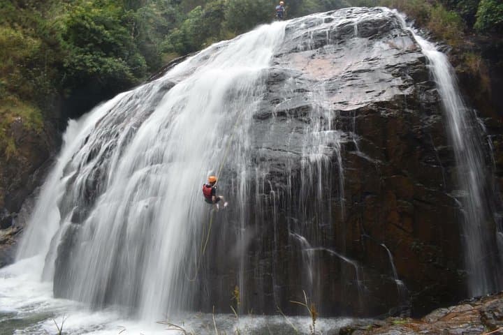
The rope takes weight. For a half-second the world narrows to the hiss of water and the rough braid of nylon in your hands; the waterfall seems to lean toward you, daring you to keep moving. Down below, the pool swallows the light and throws it back in quick, glassy flashes. This is canyoning in Da Lat: a half-day of controlled chaos where cliffs, streams, and a team of trained guides choreograph a route through places the road never reaches.
Da Lat sits on the Lang Biang Plateau—an uplifted sweep of basalt, red soil and pine forest that feels more French Riviera than tropical Vietnam. The city itself is a relic of colonial ambition: a cool mountain town the French engineered in the early 20th century as a retreat from lowland heat. The geology that made it attractive also created the conditions for canyoning—steep valleys carved by runoff, waterfalls fed by monsoon rains and compact basalt cliffs that hold anchors true. Locals from K’Ho and other highland ethnic communities call this landscape home; their agricultural terraces and vegetable farms are stitched into the hillsides, a human counterpoint to the raw mechanics of water carving stone.
On a canyoning route, every element feels like it has agency. Runnels push you toward swim exits, mossed ledges insist on careful footwork, and the waterfall mouths offer both refuge and the next challenge. The sport blends simple mountaineering—knots, harnesses, controlled descents—with the playful physicality of swims, slides and the occasional jump. You don't need previous experience; guides teach knotwork, harness fit and abseil technique, but you do need a steady sense of balance and a willingness to lean into the unknown.
The VIP Adventure Tour in Da Lat packages this in a six-hour loop that starts with a short drive from town, a safety briefing, and then a steady move into the gorge. Expect multiple rappels (some vertical, some leaning), downclimbs, natural slides and swim legs. Guides rig anchors and lower ropes where the rock won't allow a foothold—everything is professional and safety-focused, but the route still asks you to participate: choose your line, trust your belayer and commit to the jump.
Practical details matter here. The water is cool year-round—Da Lat's elevation (about 1,500 meters) tempers tropical heat—so you won't find warm baths in the pools. Grip is earned: good sticky-soled shoes and neoprene socks, when paired with harnesses and helmets, make a dramatic difference. Expect variable cell service once you drop below the tree line; photographers should bring tethered cameras or waterproof housings. The operator provides technical gear, and pricing starts around USD 105 per person, which covers training, equipment and guiding for the day.
If you’re planning the trip, time it with weather and water levels. The dry season (roughly December through April) offers safer, clearer routes, while the shoulder months after rains can make for higher flows and more adrenaline. Regardless of season, arrive hydrated, with layers—morning starts in the high country are brisk—and a small personal dry bag for keys and a phone if you want pictures at the base.
Beyond the ropes, Da Lat rewards patience. Post-canyon, the city is a short return drive away: grab a coffee made from locally grown beans, hunt down a plate of bánh căn (mini savory pancakes) at a street stall, or wander the night market for artfully candied fruit and grilled meats. For longer stays, explore the surrounding trails and waterfalls by mountain bike or a day hike up the Lang Biang massif.
Safety and stewardship go hand in hand. Use a reputable operator that inspects ropes and anchors and keeps group sizes manageable. Respect the stream ecology—avoid soap in pools, pack out any trash and listen to your guides about where foot traffic is allowed. These ravines are both playground and fragile ecosystem; low-impact behavior keeps routes open and wildlife undisturbed.
Canyoning in Da Lat is not a performance for spectators. It’s a craft you practice in small increments, a day where technical skill meets childlike impulse to slide, leap and swim. If you go with open curiosity, you’ll leave with a clearer sense of how water shapes land, how the highland culture of central Vietnam lives adjacent to raw terrain, and a physical reminder—a rope burn, a grin, a soaked shirt—of having answered a waterfall’s invitation.
Trail wisdom
Small choices, better day.
Wear grippy shoes
Closed-toe shoes with sticky rubber will handle wet rock far better than hiking sandals.
Hydrate before you start
Six hours of activity at elevation is taxing—drink water before the briefing and carry a small bottle in a dry bag.
Trust the training
Guides will teach knots and abseil technique—listen closely and ask questions before committing to a descent.
Protect your camera
Use a waterproof housing or tether your device—drops and splashes are common in gorge environments.
Local knowledge
Read the place, not just the route.
Watch for native species including River fish and freshwater crabs, Forest birds such as barbet and warbler species.
Keep an eye out for wildlife during the transition between areas and habitats. Respect distance guidelines.
Operators are encouraged to minimize impacts on riparian zones; pack out waste, avoid soaps in pools and support local guides who prioritize sustainable route use.
Follow the guide's instructions on size limits, ethical handling, and leave-no-trace practices.
Hoa Hiep Valley waterfalls (less-visited cascade sections). Early morning market stalls in Da Lat for fresh strawberries and coffee
Locally recommended viewpoints and quiet spots known best to local operators.
Da Lat was established as a French hill station in the early 1900s and remains a distinctive mix of colonial-era villas and highland agricultural communities.
Maritime roots and regional tradition shape the waterways and working coasts.
Seasonal guide
Four versions of the same landscape.
Spring
Best forStable dry weather · Clear water visibility · Post-monsoon freshness
ChallengesCool mornings · Lower water volume in some streams
March–May brings comfortable temperatures and reliable conditions for technical rappels and swims, with days that feel like the highlands should.
Summer
Best forLush scenery · Stronger water flows (more dramatic descents) · Dense vegetation colors
ChallengesHeavy afternoon rain · Higher river flows can close some routes
June–August is lush and green—expect unpredictable rain and occasional route adjustments for safety.
Fall
Best forColorful forests · Comfortable temperatures · Lower visitor numbers
ChallengesEarly-season rains in some years · Variable water levels
September–November is transitional; choose days carefully for stable flows and cooler weather.
Winter
Best forClear skies · Cool, crisp mornings · Reliable lowland reprieve
ChallengesCold water temperatures · Shorter daylight hours
December–February offers the driest footing and calmest weather but expect cold pools—wear layers and neoprene where possible.
Operator details
What the booking data adds.
Included
- ✓Local luch- Vietnamese food, water, tea and snacks..
- ✓Air-conditioned vehicle
- ✓All equipment: wetsuit, harnesses, carabiner& figures 8, jackets, helmets...
Not included
- —Gratuities
- —Personal expenses
Good to know
- ✓Public transportation options are available nearby
- ✓Not recommended for travelers with spinal injuries
- ✓Not recommended for pregnant travelers
- ✓Not recommended for travelers with poor cardiovascular health
- ✓Travelers should have at least a moderate level of physical fitness
Pack with intention
What to bring.
Good to know
Common questions.
No. Guides provide hands-on training in harness use, knots and abseil technique; basic fitness and a willingness to learn are sufficient.
Plan the edges
The details that make the day easier.
Da Lat sits at roughly 1,500 meters elevation and was developed by the French as a cool-weather retreat in the early 20th century.
After the canyon, head back to Da Lat market for fresh strawberries and yogurt, sip locally roasted coffee at a café near Xuan Huong Lake, or try bánh căn and grilled skewers at a street stall to reconnect with the highland food scene.
- Closest airport
- Lien Khuong Airport (DLI) ~30–45 minutes drive; Driving distance from Da Lat city center: typically 20–60 minutes depending on route; Cell service: limited to none inside gorges; Permits: none required for private visitors—operator handles access and safety.
These gorges are sensitive freshwater ecosystems—avoid soap, pack out trash, stay on established lines and choose operators who use removable anchors to minimize rock impact.
Explore by topic
Follow the threads.
Keep exploring
Make the story part of the trip.
Set out from Bass Harbor for a private, customizable day on Blue Hill Bay — lighthouses, puffins, seals, and the chance to feel Acadia from the water. Small groups, local captains, unforgettable views.
In four hours you can move from shaded canyon ferns to wind-scoured coastal ridgelines, guided by someone who knows where the light—and the hidden views—live. This private half-day hike on the Monterey Peninsula or Big Sur is compact, curated, and perfect for travelers who want depth without a multiday commitment.
 Related story
Beneath a sky of shifting light, Skaftafell’s ice reads like a map of time. This three-hour guided glacier hike mixes technical instruction with geology and culture: compact, safe, and unforgettable.