
What the day feels like
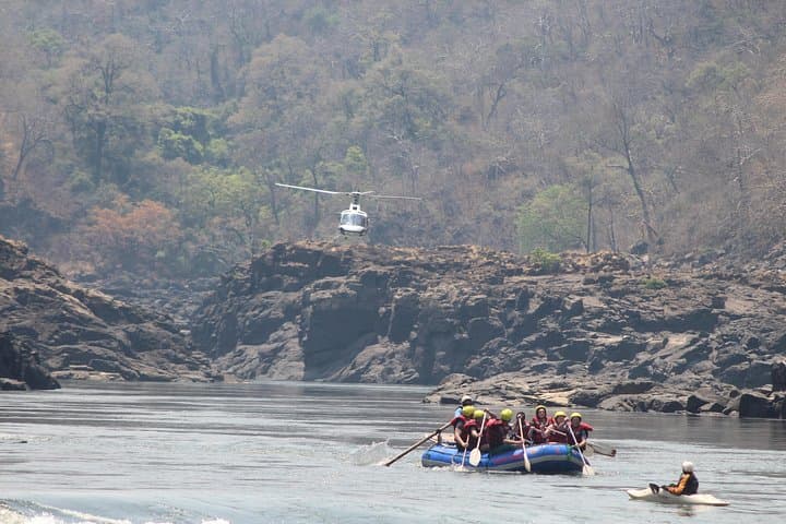
You feel the river before you see it. It arrives as a low roar at first, then a throat-deep roar, the sound of water funneled into a black ribbon between basalt walls. The Batoka Gorge opens in a narrow throat below Victoria Falls and, for three to four hours, the Zambezi dares you to match its pace. Paddles bite, the current answers, and the cliff faces — sun-baked and streaked with mineral veins — close in until the sky is a slash above.
This is not an idyllic float. It is a compact, focused hit of adrenaline: 11 kilometers of class 4 and 5 rapids, sudden drops and explosive hydraulics, and small windows of calm where the guides narrate the gorge's geology and the stories of the river. Participants come away damp, exhilarated, and with a sharper sense of how small a person is beneath such persistent forces. For the inexperienced rafter the trip is challenging but accessible; for the seasoned paddler it is a reminder that the Zambezi does not yield to ego.
The geography tells most of the story. The Batoka Gorge was carved as the Zambezi worked through ancient basalt flows. Over millennia, the river sliced a deep, winding trench into the lava rock, creating the vertical cliffs that channel its power today. Victoria Falls — upriver and visible before the descent if you know where to look — gives the Zambezi the height, volume, and headwaters that turn ordinary flows into the technical rapids below.
Culturally, the valley has long been homeland to Tonga communities whose lives have been shaped by the river's rhythms. Colonial-era maps and hydro projects later brought engineers and explorers, but the names passed down locally — of pools, ledges, and rapids — remind you that this waterway has always belonged to people as well as geology.
The guides tell stories on the quieter stretches: how seasonal rains can reorganize a half-mile of riverbed overnight, how certain eddies hold catfish the size of elbows, and why the right foot on the paddle at the right moment changes everything. Safety is constant: life jackets, helmets, swift rescue drills, and a pre-run briefing that is both professional and direct. For most groups the run becomes a study in teamwork — the raft responds only when everyone commits.
Why go? Because the Zambezi balances scenery and intensity better than many famous rivers. The cliffs create a sense of being inside a natural amphitheater; the rapids are concentrated and technical, offering hard, clean lines rather than endless bruising. It is an efficient rush: in half a day you get the raw movement of a big African river without committing to an overnight expedition.
Practicalities matter. The trip covers 11 km and typically takes 3–4 hours door to door on the water, though a full morning or afternoon block of time is required for transfers, safety briefings, and gear. Operators meet in Victoria Falls town, usually close to Victoria Falls Airport; from there it is a short drive to the put-in. Guides provide helmets, life jackets, and radios for support; waterproofing for phones and cameras is your responsibility unless the operator specifies otherwise.
Timing matters by the calendar. The Zambezi is driven by a wet and dry season rhythm; higher flow after rains means bigger, more powerful rapids while the dry months lower the river and make some features more technical. Choose your season based on whether you want raw volume or technical lines. Book early in high season, and confirm cancellation policies — many operators offer free cancellation up to a certain point, but the river does not follow anyone's schedule.
For those planning their first run, a few hard lessons cut the learning curve: listen to the guides, keep the heel of your feet wedged into the raft for bracing, and accept that falling out of the boat is a worked risk — not the end of a trip but part of the process. Drink water before you go; even when you are cold and wet, dehydration steals energy and focus.
After the run, the town of Victoria Falls eases you back into civilization with cafés, craft markets, and cold beer. There are places to buy a meal that centers on grilled meat and fresh salads, and a handful of riverside eateries where you can watch the Zambezi keep going.
If you are imagining a postcard, replace it with the real thing: a river that pushes, a gorge that channels, and a brief, intense window where the landscape demands attention. It's efficient, memorable, and — with the right preparation — entirely doable for adventurous travelers with a taste for moving water.
Trail wisdom
Small choices, better day.
Hydrate before you go
Drink water in the hour before launch; being cold and wet masks dehydration and drains energy on technical runs.
Wear closed-toe water shoes
Rubber-soled river shoes or old trail runners protect toes and provide grip in the raft and when scrambling on rocks.
Listen to the safety briefing
Guides cover commands and what to do if you go overboard — paying attention can change a tumble into a quick recovery.
Protect electronics
Use a waterproof case or dry bag; the best shots are often from the shore after the run rather than mid-rapid.
Local knowledge
Read the place, not just the route.
Watch for native species including African fish eagle, Monitor lizard.
Keep an eye out for wildlife during the transition between areas and habitats. Respect distance guidelines.
Operators often follow a leave-no-trace ethic and contribute to local communities; avoid single-use plastics and support guides who engage in sustainable practices.
Follow the guide's instructions on size limits, ethical handling, and leave-no-trace practices.
Quiet viewpoints above the gorge where you can watch rafts thread the rapids. Small riverside pools downstream where guide crews cool off and share stories
Locally recommended viewpoints and quiet spots known best to local operators.
The Batoka Gorge was formed as the Zambezi cut through ancient basalt flows; local Tonga communities have lived along its banks for centuries and the river has long been central to their livelihoods.
Maritime roots and regional tradition shape the waterways and working coasts.
Seasonal guide
Four versions of the same landscape.
Spring
Best forLower to mid river flows · Photography of clifflight · Fewer mosquitoes
ChallengesVariable weather during transition months · Occasional higher flows early in the season
Southern-hemisphere spring (September–November) brings warming temperatures and transition flows — a sweet spot for technical lines without the full wet-season surge.
Summer
Best forBig water and powerful rapids · Lush riverside vegetation · High-adrenaline runs
ChallengesHot, humid conditions · Rain can make logistics harder and raise water levels rapidly
Summer (December–February) is wet and warm; expect larger-volume rapids and occasional logistical delays after storms.
Fall
Best forStable late-season flows · Clear skies and warm days · Lower river hazards
ChallengesCooler mornings and nights · Some sections may be more technical as the river lowers
Fall (March–May) sees the river falling from its wet-season highs — rapids become more clearly defined and scenic vantage points open up.
Winter
Best forLower flows and technical maneuvers · Cooler, clearer days · Great visibility for photography
ChallengesChilly mornings and potential for cold water · Lower water can expose sharper rocks
Winter (June–August) is dry and cool; the Zambezi is clearer and more technically demanding — perfect for paddlers seeking precise lines.
Operator details
What the booking data adds.
Included
- ✓Lunch
- ✓Transfer to and from your Hotel / place of residence
- ✓Photos and Videos
- ✓Beverages
Not included
- —National Park Fees
- —Visa
Good to know
- ✓Not recommended for pregnant travelers
- ✓Public transportation options are available nearby
- ✓Not recommended for travelers with spinal injuries
- ✓Not recommended for travelers with poor cardiovascular health
- ✓Travelers should have at least a moderate level of physical fitness
- ✓Vegetarian option is available, please advise at time of booking if required
Pack with intention
What to bring.
Good to know
Common questions.
The run includes many class 4 and some class 5 rapids; guided teams of mixed abilities can do it, but expect technical moves and a high likelihood of rough water and swims.
Plan the edges
The details that make the day easier.
The Zambezi River runs about 2,574 kilometers (1,599 miles) and the rapids below Victoria Falls carved the Batoka Gorge through basalt over millennia.
After the run, head to The Lookout Café or a riverside restaurant in Victoria Falls for grilled meat, fresh salads, and cold beer; visit the craft markets for local woodcarvings and batik textiles to support community artisans.
- Closest airport
- Victoria Falls Airport (VFA); Driving distance from town: 10–30 minutes to put-in depending on operator; Cell service: patchy once in the gorge; Permits
- passes
- operator usually handles river permits and park fees — confirm at booking.
The Batoka Gorge is a sensitive riverine environment — choose operators that minimize plastic use, carry out waste, and invest in local community programs.
Explore by topic
Follow the threads.
Keep exploring
Make the story part of the trip.
Set out from Bass Harbor for a private, customizable day on Blue Hill Bay — lighthouses, puffins, seals, and the chance to feel Acadia from the water. Small groups, local captains, unforgettable views.
In four hours you can move from shaded canyon ferns to wind-scoured coastal ridgelines, guided by someone who knows where the light—and the hidden views—live. This private half-day hike on the Monterey Peninsula or Big Sur is compact, curated, and perfect for travelers who want depth without a multiday commitment.
 Related story
Beneath a sky of shifting light, Skaftafell’s ice reads like a map of time. This three-hour guided glacier hike mixes technical instruction with geology and culture: compact, safe, and unforgettable.