
What the day feels like
Morning on the Jebel Shams plateau arrives with quiet authority. The sun slides over the rim and the canyon breathes awake, throwing blue shadow down into Wadi Ghul—the so‑called Grand Canyon of Arabia—as if to dare you deeper. The trail begins at Al Khitaym, a stony hamlet balanced above the void. A thin path scrapes along the cliff, purposeful and clear, and the mountain wind nudges you forward like a stern teacher who knows what you came for.
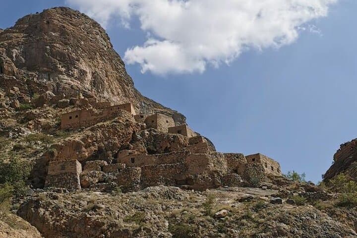
This is the Lost Village Hike, a cliff‑hugging, out‑and‑back route that threads the famous Balcony Walk to an abandoned settlement once known as As Sab. It’s a study in contrasts: a lofty trail with relatively modest elevation change; an austere limestone amphitheater that hides green terraces and a trickling falaj; a place that feels forsaken yet still murmurs with the labor of generations. The canyon walls speak in their own grammar—bedded strata stacked like ledgers of time, each layer a cool, pale sentence written in fossil‑rich carbonate. The rock keeps score; your footfall adds a brief annotation.
For the first stretch, the path skims the escarpment with airy exposure. It’s not technical, but it demands attention and respect, especially where the trail narrows above open space. Ravens ride thermals at eye level, and Egyptian vultures circle on patient loops, as if inspecting your progress. The way is almost level, angling across the face of the mountain toward a cleft where the cliff relents and the remnants of human tenacity appear—terraces, dry‑stacked walls, and the roofless stone homes of the lost village.
As Sab was never truly lost; it was simply left behind. Decades ago, families moved to easier ground when water and access became too uncertain. They left clues everywhere. You find a channel of the falaj—Oman’s ingenious gravity‑fed irrigation system, part of a UNESCO‑recognized heritage—etched into the canyon wall. You see date palms reaching shyly from terraces, still claiming moisture from seeps even in the dry months. You step into the shade of a shallow cave and hear water insisting on its route, a thin, persistent ribbon that dared a community to grow food in an unforgiving place.
Hiking here offers more than high drama. It lends perspective on the quiet endurance of the Hajar Mountains. The geology is textbook: uplifted and eroded limestone kneaded by time into a cathedral of cliffs. But it’s also personal. Every stone laid on the terraces was carried by someone who read this landscape intimately—when to plant, where to store water, how to balance risk along a cliff that tests every errand. The mountain doesn’t shout. It sets the tempo, unhurried and deliberate, and you fall into its cadence.
There are surprises tucked into the rock. Near the village, a small grotto collects a pool where the canyon’s veins gather in a cool basin. Bring swim gear and you can slip into the water as sun shards through the entrance, turning dust into slow fireworks. In the heat of summer, the pool is relief with teeth; in winter, it’s a bracing dare.
While the route is well‑trod and clearly waymarked by cairns and worn limestone, it remains a hike that rewards preparation. Footing can be loose in places, and the exposure is real. Weather swings on the plateau: summer days run hot but tolerable at elevation; winter mornings bite, and wind funnels along the wall. Start early, carry more water than you think you’ll need, and keep snacks handy—the kind of steady fuel that smooths out a long traverse.
Culturally, the hike bridges worlds. Start and finish your day in nearby Nizwa or Al Hamra, where the scent of cardamom and frankincense drifts from souqs, and where clay‑walled forts have watched trade caravans arrive for centuries. Locals know this canyon intimately; guides here don’t just point out photo ops, they share stories of migration, harvests, and how life moved when the mountains demanded a new plan. Respect is the currency: greet villagers, tread lightly on terraces, and leave everything as you found it.
Logistically, the approach is half the fun. The final kilometers to Al Khitaym are on rough track often requiring a high‑clearance vehicle—one of many reasons travelers choose a guided outing. On a full‑day experience, expect a leisurely pace: drive‑time from Nizwa, trail time on the Balcony Walk, long pauses to read the landscape, and a slow return that lets the canyon release you in its own time. Trekking poles can be arranged if you need them, and the safety brief is simple but firm: stay on the path, keep space from the edge, communicate if you’re managing heat or vertigo.
Why go? Because this hike lets you measure distance in more than kilometers. The payoff is a sweep of horizons, yes, but also an encounter with persistence—of rock, of water, of people who coaxed life from improbable ledges. The mountain sets the pace, the sun keeps score, and you get to walk the line between empty and abundant.
And when you’re back at the trailhead, boots dusted, wind combed clean through your thoughts, the canyon offers one last nudge. Come again, it seems to say. There are more sentences in the stone. You’ve only read the prologue.
Trail wisdom
Small choices, better day.
Start Early, Finish Strong
Begin hiking before the heat builds; shade fades quickly on the cliff and afternoon winds can kick up.
Mind the Edge
Sections of the Balcony Walk have airy exposure. Keep a safe distance from ledges and avoid stopping on narrow spots for photos.
Water Rules the Day
Carry at least 2–3 liters per person; there’s no reliable potable water on the trail.
Respect the Terraces
Stay off the stone walls and gardens at the village; these are cultural features, not playgrounds.
Local knowledge
Read the place, not just the route.
Watch for native species including Egyptian vulture, Nubian ibex (occasionally on distant ledges).
Keep an eye out for wildlife during the transition between areas and habitats. Respect distance guidelines.
Stay on established paths to protect fragile terrace walls and plantings; pack out all litter and avoid disturbing water channels that still support local ecology.
Follow the guide's instructions on size limits, ethical handling, and leave-no-trace practices.
The shaded grotto just beyond the village with a cool plunge pool. Ancient falaj channels carved into the cliff, remnants of ingenious irrigation
Locally recommended viewpoints and quiet spots known best to local operators.
The abandoned village of As Sab was gradually vacated in the late 20th century as families moved to more accessible areas; its terrace agriculture relied on the falaj system, an Omani tradition with UNESCO World Heritage recognition.
Maritime roots and regional tradition shape the waterways and working coasts.
Seasonal guide
Four versions of the same landscape.
Spring
Best forWildflowers on terraces · Mild temperatures
ChallengesOccasional spring winds · Unpredictable showers
Pleasant hiking with green touches in the valley; mornings stay cool and the canyon light is crisp.
Summer
Best forEarly starts with long daylight · Refreshing dip in the grotto
ChallengesMidday heat · Glare on exposed limestone
Warm to hot even on the plateau; plan dawn departures and seek shade for breaks.
Fall
Best forStable weather · Clear views after summer haze
ChallengesWarm afternoons · Peak visitor weekends
A sweet spot for visibility and comfort; arrive early for parking near Al Khitaym.
Winter
Best forCool, fast hiking · Low-angle golden light
ChallengesChilly mornings · Occasional strong canyon winds
Expect cold starts and gusts funneling along the wall; pack an extra layer and wind protection.
Operator details
What the booking data adds.
Included
- ✓Lunch
- ✓Drinking water (you can take and carry as much as you like)
- ✓Services of a professional Hiking Guide
- ✓First-Aid Kit
- ✓Certified abseiling and climbing equipment
Not included
- —Anything not mentioned in the Inclusions
- —Pick-Up Drop facility that can be arranged on request for an extra charge.
- —ENTRANCE FEES TO THE TOURIST PLACES.
Good to know
- ✓Public transportation options are available nearby
- ✓Infants are required to sit on an adult’s lap
- ✓Specialized infant seats are available
- ✓Travelers should have a high level of physical fitness
- ✓Not recommended for those who have Acrophobia / Vertigo and small kids
Pack with intention
What to bring.
Good to know
Common questions.
Plan for 7–10 km round-trip on the Balcony Walk to As Sab, typically 3–5 hours of hiking depending on pace and stops.
Plan the edges
The details that make the day easier.
Jebel Shams, home to the Balcony Walk and the Lost Village route, is Oman’s highest mountain at about 3,009 meters, and Oman’s aflaj irrigation systems are inscribed on the UNESCO World Heritage List.
Post-hike, head to Nizwa Souq for Omani coffee (qahwa) and halwa, or sit down to a plate of tender shuwa or chicken mandi at a local restaurant in town. If you’re overnighting on the plateau, simple but hearty meals at Jebel Shams Resort or Sama Heights pair well with sunset views over the canyon.
- Nearest airport
- Muscat International (MCT). Trailhead: Al Khitaym village above Wadi Ghul. Drive: ~2 hours from Nizwa, final 7–10 km on rough gravel (4x4 recommended). Cell service: Spotty to none on the traverse. Permits: None required; follow posted guidance and local customs.
This canyon’s terrace gardens and falaj channels are part of a living heritage—do not walk on walls, avoid soaps in natural pools, and pack out all waste. Stick to the main path to reduce erosion on the fragile slope.
Explore by topic
Follow the threads.
Keep exploring
Make the story part of the trip.
 Related story
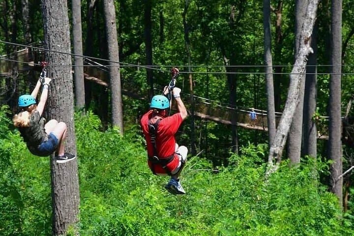
Less than two hours from Nairobi, Kereita Forest pairs hands-on canopy adventure with quiet montane trails and a sobering colonial history—perfect for families, teams, and curious travelers seeking a full-day pulse of nature.
Set out from Bass Harbor for a private, customizable day on Blue Hill Bay — lighthouses, puffins, seals, and the chance to feel Acadia from the water. Small groups, local captains, unforgettable views.
In four hours you can move from shaded canyon ferns to wind-scoured coastal ridgelines, guided by someone who knows where the light—and the hidden views—live. This private half-day hike on the Monterey Peninsula or Big Sur is compact, curated, and perfect for travelers who want depth without a multiday commitment.