
What the day feels like
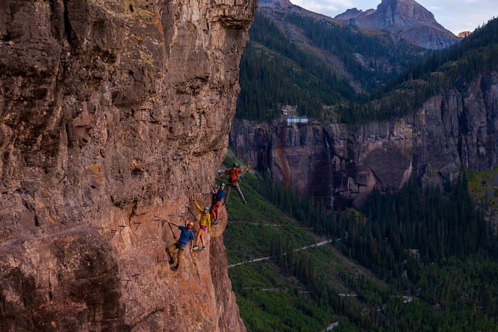
You step out of town into thin, cold sunlight and the San Juan peaks close like a cuff around Telluride. The trail heads up through spruce and aspen, the air sharpening with altitude; below, the town’s grid shrinks and the river threads silver through the box canyon. In an hour the path narrows, and the rock face—already ancient and pocked with ice-age scars—leans toward you. The steel cable appears as if stitched into the stone, a bright, human-made lifeline against a vertical world. This is the Telluride Via Ferrata: a high-alpine traverse that takes you along iron rungs and cables, sometimes 600 feet above the valley floor, with Bridal Veil Falls roaring nearby and the town of Telluride perched like an afterthought far below.
Via ferrata—Italian for “iron path”—is a hybrid of hiking and climbing. It’s a way to access exposed rock that would otherwise demand technical climbing skills. The Telluride route threads cliffs that bear the geology of the San Juan Mountains: volcanic breccia and andesite carved by glaciers and rivers over millions of years. The rock takes color from iron and copper traces; in afternoon light it glows ocher. Bridal Veil Falls, the state’s tallest free-falling waterfall, slices down the mountain in a constant plume; when the wind shifts the spray fans across the route and the falls almost feels alive, daring you onward.
History and culture here braid together. Telluride is a former mining town that boomed in the late 19th century, and the San Juans still keep the memory of that era in old miner roads and rusting flumes. The via ferrata itself is a modern intervention—engineered anchors and cable systems added to make an Old World climbing method accessible in the West. Local outfitters run the private trips, blending a guide’s mountain craft with a hospitality ethic that keeps access and safety in the foreground.
Why come? The view is obvious: a sweep of jagged peaks and hanging glaciers, the tumbling Bridal Veil Falls, and a vantage point over Telluride that feels like you’ve climbed into a postcard. But the route also changes how you move. You’re on a fixed line; the landscape feels less like a backdrop and more like a partner—rock that accepts your weight, wind that nudges your balance, gravity that demands attention. For people who want to push beyond trailwalking without committing to multi-pitch trad climbing, via ferrata is an elegant middle ground.
Practical snapshot: the experience runs about five hours from meeting to return (operator time listed at 300 minutes), typically includes guided instruction, harness and via ferrata kit, and transport to the route. Tours are private and offer instant confirmation; current base pricing starts around USD 264 per person. The route’s exposed sections reach up to 600 feet above the valley floor. Expect a stiff approach: plan on roughly 1–2 miles of hiking plus the technical forge along the cliff, with cumulative elevation gain in the neighborhood of several hundred feet (exact figures vary by guide and approach line).
Safety and rhythm: the first 20–30 minutes of the route are practical lesson—fitting a harness, clipping a via ferrata lanyard to the cable, and learning efficient, deliberate movement. Guides emphasize three fundamentals: keep two points of contact, clip and unclip methodically at anchor stations, and maintain measured breathing—altitude and exposure are equal-opportunity agitators. Wear sturdy, grippy shoes (approach or light hiking shoes) and layers for sudden wind; a light helmet is standard provided gear.
Timing matters. Mid-summer days give the most stable weather and longest daylight windows; late afternoon can bring fast storms. Because the route is exposed and near a waterfall, plan for spray on the cliff and cooler temps than in town. Hydrate early—altitude lowers your hydration threshold—and carry snacks that you can eat while clipped in, like bars and compact sandwiches. Guides typically split time between guided climbing on the fixed line and short, interpretive stops that outline local geology and mining history.
Logistics and access are straightforward but worth a moment of planning. Telluride has a small regional airport with limited seasonal service; most travelers fly into Montrose Regional Airport and drive about 70–90 minutes into the mountains. Guided operators meet in town and shuttle to the trailhead; parking is limited near the falls. Cell service is unreliable on the cliffs; share your plans with someone in town and charge your devices ahead.
The experience leaves you with a few practical takeaways: exposure is mental as much as physical—trust your gear and your guide. The activity is accessible to fit, adventurous people who are comfortable with heights but not necessarily with climbing systems. Bring a compact camera (with a wrist strap), warm layers, and a patient curiosity—most of the best vistas are earned.
After the descent there’s real pleasure in a slow return: burger and fries in town, a pint at a local spot, and the easy humor of people who have just stared over a cliff and lived to tell it. The Telluride Via Ferrata is not a death-defying headline stunt; it’s a deliberate, engineered way to access a wild, rocky theater with safety and perspective. For travelers who want views that flatten Instagram and technique that expands competence, it’s a tight, efficient, thrilling five-hour investment in becoming more capable outside.
Trail wisdom
Small choices, better day.
Trust the System
Always stay clipped to the cable; clip one carabiner before you unclip the other at anchor points.
Bring Grippy Shoes
Approach shoes with sticky rubber or light hiking shoes offer traction on iron rungs and wet rock near the falls.
Hydrate Before You Start
Drink plenty of water before the climb—altitude and effort combine quickly on exposed routes.
Plan for Weather Windows
Start in the morning to avoid afternoon thunderstorms; the route is exposed and lightning is a significant risk.
Local knowledge
Read the place, not just the route.
Watch for native species including Mule deer, Golden eagle.
Keep an eye out for wildlife during the transition between areas and habitats. Respect distance guidelines.
Operators emphasize Leave No Trace principles and group size limits to protect fragile alpine vegetation; avoid trampling meadows and pack out all waste.
Follow the guide's instructions on size limits, ethical handling, and leave-no-trace practices.
Hike the lower Jud Wiebe Trail for wildflower meadows and mountain views. Drive the scenic road to Alta Lakes for quieter alpine fishing and vistas
Locally recommended viewpoints and quiet spots known best to local operators.
Telluride was a 19th-century mining boomtown; many trails and roads follow old miner routes and flume beds dating to that era.
Maritime roots and regional tradition shape the waterways and working coasts.
Seasonal guide
Four versions of the same landscape.
Spring
Best forFewer crowds · Wildflower displays · Lower lodging rates
ChallengesSnow patches on the approach · Unpredictable weather · Cold spray from the falls
Late spring can offer dramatic water flow from snowmelt and blooming aspens, but expect lingering snow and colder conditions—confirm availability with guides.
Summer
Best forStable weather · Full waterfall flow · Long daylight hours
ChallengesAfternoon thunderstorms · Higher visitor numbers · Warm daytime temperatures in town
Summer is the optimal season with the most consistent conditions—book early for private trips and start early to avoid storms.
Fall
Best forFall color in aspens · Crisp, clear air · Smaller crowds
ChallengesShorter days · Early snow possible · Cooler temperatures on exposed rock
Autumn’s golden aspens make the approach spectacular; be ready for colder temps and possible snow at higher elevations.
Winter
Best forSnowy vistas from town · Off-season solitude · Combination tours for experienced climbers
ChallengesRoute typically closed or technical ice conditions · High avalanche risk · Requires winter climbing skills
Winter conditions generally make the via ferrata unsafe for standard guests; only expert, specifically equipped guided parties should attempt it in snow and ice.
Operator details
What the booking data adds.
Included
- ✓Use of all climbing equipment (harness, helmet, Via Ferrata-specific lanyard, pack if needed, etc.)
Not included
- —Personal clothing and footwear
- —Guide gratuity
- —We do not provide lunch while on the route. We also do not provide bottled water for environmental reasons.
- —Private transportation
Good to know
- ✓Not recommended for travelers with spinal injuries
- ✓Not recommended for pregnant travelers
- ✓Not recommended for travelers with poor cardiovascular health
- ✓Travelers should have at least a moderate level of physical fitness
- ✓Not recommended for children younger than 10 years old or shorter than 5'0".
- ✓Not recommended for those with a severe fear of heights.
- ✓Participants should have a reasonable level of fitness, and be capable of hiking an uneven, rocky trail at above 10,000'.
Pack with intention
What to bring.
Good to know
Common questions.
No technical climbing background is required—guided trips teach the via ferrata safety and movement techniques. Comfortable balance and no severe fear of heights are helpful.
Plan the edges
The details that make the day easier.
Bridal Veil Falls in Telluride is Colorado’s tallest free-falling waterfall, plunging approximately 365 feet—an iconic landmark you’ll see from the via ferrata.
After the climb, head into Telluride’s compact downtown for craft beer and hearty mountain fare, sample locally sourced trout or game, and stroll the historic district to connect the adventure with the town’s mining-era roots.
- Closest airport
- Telluride Regional Airport (seasonal)
- Montrose Regional (MTJ, ~70–90 minutes). Trailhead
- shuttle or short drive from Telluride town center. Cell: spotty to none on the cliffs. Permits: none required for guided trips—confirm parking regulations with your operator.
This is fragile alpine terrain—stick to anchored routes, avoid chalking the rock, pack out all trash, and support outfitters who follow Leave No Trace and minimal-impact practices.
Explore by topic
Follow the threads.
Keep exploring
Make the story part of the trip.
In four hours you can move from shaded canyon ferns to wind-scoured coastal ridgelines, guided by someone who knows where the light—and the hidden views—live. This private half-day hike on the Monterey Peninsula or Big Sur is compact, curated, and perfect for travelers who want depth without a multiday commitment.
 Related story
Beneath a sky of shifting light, Skaftafell’s ice reads like a map of time. This three-hour guided glacier hike mixes technical instruction with geology and culture: compact, safe, and unforgettable.
 Related story
Lose the city for a few hours without leaving it: this 5-mile, 900-foot-gain Forest Park loop threads old-growth pockets, city viewpoints, and cultural landmarks for a compact taste of Portland’s wild side. Expect moss, roots, and stories.