
What the day feels like
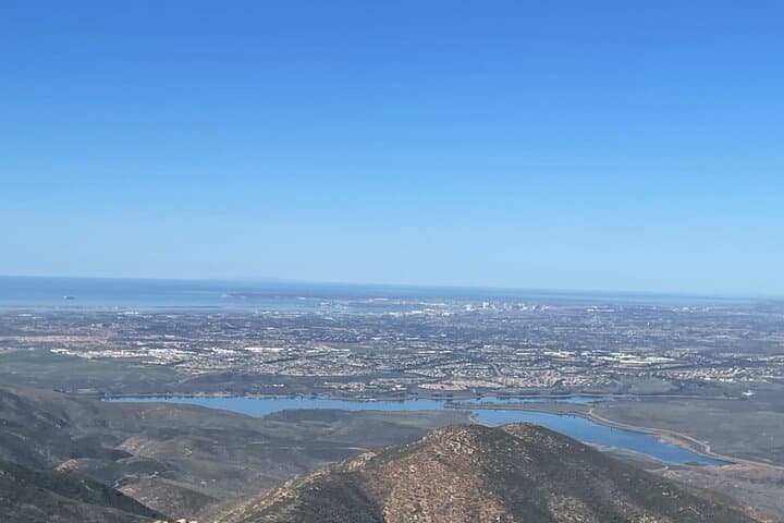
You crest a dusty ridge and the city unfurls below like a living map — the blue scrape of San Diego Bay, the tidy grid of neighborhoods, and beyond them, a patchwork of roofs and lights that is Tijuana. Wind rips at your jacket and the Land Cruiser beneath you hums with quiet confidence; your guide gives a nod, not orders. Here, on the western edge of the Otay Wilderness, the borderlands feel less like a line on a map and more like a living seam where chaparral, coastal sage, and open sky press against one another.
San Diego Off Road Tours trades postcard panoramas for something a little rougher and more immediate: steep ascents that test your nerve, rocky switchbacks that rattle the teeth, and overlooks where you can stand with your hands on the hood and watch the Pacific light change in minutes. The company runs private, guide-led drives in Toyota Land Cruisers (you drive, they coach), offering three trail grades — beginner, intermediate, and advanced — so a mixed group can share the ride without leaving anyone behind.
The Otay area is a study in sharp contrasts. Geologically, it’s the western flank of a chain of low coastal mountains shaped by tectonic uplift and long erosion, where volcanic bedrock and alluvial fans create jarring terrain and abrupt viewpoints. Ecologically, the uplands support coastal sage scrub and pockets of oak, a habitat that once sustained the Kumeyaay people who have lived here for millennia. Modern history is layered on top: military training grounds, border infrastructure, and conservation efforts that have tried to protect this fragile landscape even as recreational use grows.
Off-roading here is less about tearing across an open desert and more about negotiating a tight, technical landscape. Trails trace old vehicle tracks and access roads, climb ribs of shale and chaparral, and drop into washes where the salt-etched air from the bay meets dryer inland breezes. Guides from San Diego Off Road Tours know when to push and when to ease up; they’ll talk you through high-lift maneuvers, low-gearing descents, and how to read a trail like an open book — where to feather the throttle, where to keep your hands steady, and how to use weight transfer to your advantage.
Why do this instead of a scenic drive or a guided hike? Because you get the intimacy of a rugged place without giving up the ability to actually see it. The vehicles reach points that hikers rarely access, and because the experience is private you get time to linger — to watch a red-tailed hawk quarter the slopes, search for small lizards sunning on rocks, or simply listen while the guide explains the layers of human and natural history that shaped the view. And for many, the thrill of driving a capable 4x4 in challenging terrain is an achievement of its own: steep climbs that demand concentration, descents that mandate trust in your tools and the person beside you.
Practical reality is part of the appeal. Tours run roughly 2–4 hours depending on the route chosen, and the price reflects the private, hands-on nature of the experience. Vehicles are modern and well-maintained; guides supply instruction, safety briefings, and local knowledge. Bring a valid driver’s license — you’ll be behind the wheel — and come ready for sun, dust, and the chance of variable cell service. The border is literally visible from many vantage points, so conversations will often drift to cross-border ecology, enforcement history, and how the landscape links two countries.
If you’re planning this trip, pick a trail level that matches your appetite for technical driving: beginners can enjoy gentler climbs and wide viewpoints, while experienced off-roaders can opt for narrow ledges and steeper pitches. Timing matters — mornings are cooler and light is better for photography; late afternoons bring dramatic shadows but also a lower margin for error. Wear sturdy shoes, layer for wind and sun, and carry more water than you think you’ll need. Your guide will carry recovery gear and radios, but personal preparedness makes everything easier and safer.
The Otay experience pairs well with a broader San Diego itinerary: spend the morning on the trail and the afternoon exploring Chula Vista’s waterfront or South Bay eateries. The ride gives you a new perspective on a city you might otherwise only know from the beach — one that is defined as much by cross-border dynamics and desert ridgelines as by surf and sea.
This is not a wild, unregulated playground. The Otay Wilderness and surrounding open spaces are ecologically sensitive; responsible operators balance access and conservation, and you’ll be asked to stay on designated routes and respect wildlife. In return, you get a rare vantage: a place where two cultures and two landscapes meet, visible from a dusty ridge under a huge California sky. If you like driving, if you like geology, if you like being where maps suddenly make less sense and the land speaks in ridgelines and washes, this half-day off-road tour is a focused, efficient way to taste the borderland on its own terms.
Trail wisdom
Small choices, better day.
License and Liability
Bring a valid driver’s license — guests drive under guide supervision and proof of ID is required.
Tire Prep
Reduce tire pressure slightly for better traction on rocky sections but follow guide instructions for safe re-inflation afterward.
Hydration & Sun
Carry at least 1–2 liters of water per person and wear sun protection — the inland exposure is intense even on cool days.
Respect the Route
Stay on designated tracks to protect sensitive vegetation and avoid creating new erosion channels.
Local knowledge
Read the place, not just the route.
Watch for native species including Coyotes, Raptors (e.g., red-tailed hawk).
Keep an eye out for wildlife during the transition between areas and habitats. Respect distance guidelines.
The area contains sensitive coastal-scrub habitats; operators emphasize staying on routes, packing out trash, and minimizing off-track travel.
Follow the guide's instructions on size limits, ethical handling, and leave-no-trace practices.
Otay Ridge overlook with sunrise views over San Diego Bay. Seasonal chaparral pockets where spring wildflowers concentrate
Locally recommended viewpoints and quiet spots known best to local operators.
The Otay landscape sits on ancestral Kumeyaay territory and later became a mosaic of ranchland, military use, and protected open space.
Maritime roots and regional tradition shape the waterways and working coasts.
Seasonal guide
Four versions of the same landscape.
Spring
Best forWildflower viewing · Mild temperatures · Photographic light
ChallengesOccasional muddy washes after storms · Higher visitor traffic on weekends
Spring offers the mildest weather and bursts of wildflowers; trails can be slippery in places following rain.
Summer
Best forLonger daylight hours · Clear views · Evening rides
ChallengesHigh heat midday · Increased risk of vehicle overheating · Sparse shade
Summer brings strong sun and heat — schedule early morning or late afternoon runs and pack extra water.
Fall
Best forStable weather · Fewer crowds · Crisp air for photography
ChallengesPotential for Santa Ana winds · Rapid temperature swings
Fall is often the most stable season for off-roading, with good light and cooler temperatures.
Winter
Best forCooler technical driving · Dramatic skies after storms
ChallengesOccasional trail closures after heavy rain · Muddy, slick sections
Winter can be excellent for adventurous drivers but expect mud and the possibility of route changes after storms.
Operator details
What the booking data adds.
Included
- ✓Guide-led trip lasting 2-4 hours with stops at various way-points
- ✓Exclusive use of one of our Land Cruisers
Good to know
- ✓Public transportation options are available nearby
- ✓Not recommended for travelers with spinal injuries
- ✓Not recommended for pregnant travelers
- ✓Not recommended for travelers with poor cardiovascular health
- ✓Suitable for all physical fitness levels
Pack with intention
What to bring.
Good to know
Common questions.
Yes — guests will be driving the vehicle and must present a valid driver’s license before departure.
Plan the edges
The details that make the day easier.
Otay Mountain reaches roughly 3,568 feet and forms a prominent local high point on San Diego’s borderlands, offering panoramic views that include both San Diego Bay and Tijuana.
After the ride, head to South Bay for fresh seafood tacos or a craft beer in Chula Vista — local spots highlight Baja-influenced flavors and the cross-border culture that shapes the region.
- Closest airport
- San Diego International (SAN). Typical drive from downtown San Diego: 30–45 minutes depending on traffic. Cell service: variable on ridgelines. Permits
- passes
- none required for private tour, but respect posted closures and protected areas.
This operator runs on designated routes to limit erosion; practice Leave No Trace, pack out trash, and avoid disturbing native plants and wildlife.
Explore by topic
Follow the threads.
Keep exploring
Make the story part of the trip.
Set out from Bass Harbor for a private, customizable day on Blue Hill Bay — lighthouses, puffins, seals, and the chance to feel Acadia from the water. Small groups, local captains, unforgettable views.
In four hours you can move from shaded canyon ferns to wind-scoured coastal ridgelines, guided by someone who knows where the light—and the hidden views—live. This private half-day hike on the Monterey Peninsula or Big Sur is compact, curated, and perfect for travelers who want depth without a multiday commitment.
 Related story
Beneath a sky of shifting light, Skaftafell’s ice reads like a map of time. This three-hour guided glacier hike mixes technical instruction with geology and culture: compact, safe, and unforgettable.