
What the day feels like
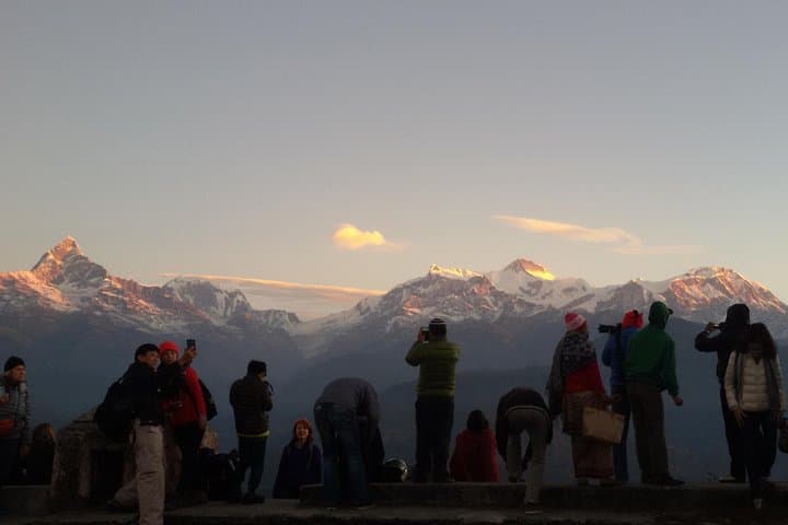
At 5 a.m., Pokhara is a hush of clinking teacups and the faint hiss of scooters. The lake still dreams, a mirror draped in mist. Up above, Sarangkot waits—a dark ridgeline that keeps its promises. By the time your jeep zigzags the last switchback and the tea stalls flick on their bulbs, the Himalaya begins to stir. Fishtail—Machhapuchhare—tilts its double summit into the indigo, and the white wall of Annapurna lights up in stages, as if someone is slowly turning the day’s dimmer switch.
You wrap your hands around a hot cup, the steam arguing with the cold. Guides chat quietly, roosters announce themselves from terraced farms, and you claim a spot along the viewpoint railing. Then it happens—the line of peaks from Dhaulagiri in the west to Annapurna II in the east blushes, the ridges take shape, and the valley below exhales. Phewa Lake drifts out of the shadows. The mountains don’t shout here. They nod, steady and certain, as if to say: walk with us.
After a simple breakfast—fresh chapati, eggs, a second tea—you shoulder a small pack and step onto the ridge path that links Sarangkot to Naudada. The trail keeps a casual conversation with the hillside, weaving between stone stairways, pine stands, and quiet courtyards where buffalo chew and children wave on their way to school. The ridgeline walks you west, sometimes on old footpaths, sometimes on village lanes. Your feet drum the same routes traders once took between Kaski’s hilltop forts and the valley floor.
Geography steers the day. Sarangkot’s crest sits around 1,592 meters; Naudada hovers lower on the ridge, so the net is a gentle descent with a few honest rollers. Expect 8–10 kilometers from viewpoint to Naudada, with roughly 200 meters of net descent and 200–300 meters of cumulative gain on the ups and downs. The stone steps are sturdy but slick with morning dew, and the terraces ask you to mind your edges. The path is never far from a tea house—wooden benches, brass kettles, packets of biscuits lined like soldiers. Order another cup, and the trail waits patiently outside the door.
Culture threads through the hike: a hillside shrine wrapped in fresh marigolds; prayer flags worrying the breeze; the sing-song exchange of Nepali greetings. The ridge passes near Kaskikot, once a hill fort controlling trade in the Kaski Kingdom before Nepal’s unification. Today, it’s a village of slate roofs and citrus trees, where a grandmother may invite you to taste a slice of orange so sweet the morning leans in for a second bite.
From the ridge, geology reads like an open book. Those gleaming faces to the north are not just pretty—they’re restless rock pushed upward by the collision of the Indian and Eurasian plates. Dhaulagiri’s pyramid seems to float beyond the middle hills, a reminder that these foothills are merely the foyer of the Himalaya’s great house. Far below, the Seti River saws through limestone, carving a gorge you’ll barely notice from this airy perch.
The rhythm of the hike is unhurried. Paragliders lift off from nearby meadows and drift like bright punctuation against the pale peaks. Dogs trot alongside for a stretch, then peel off to their home courtyards. The sun, once timid, grows bold by late morning, leaning hard on exposed sections. The trail answers with shade—pines and banyans and the occasional mud-plastered chautara, those stone wayside rests that have served travelers here for centuries.
By the time Naudada’s junction comes into view—a confluence of trails, jeeps, and the promise of lunch—you’ve earned the quiet in your legs. The mountains keep watch, their midday faces still crisp in fall and winter, softer in spring and summer haze. You could push farther, but the day has already delivered: sunrise that felt like a private showing, a ridge that taught you to move with the land, and a living soundtrack of village life that welcomed you without ceremony.
The beauty of the Sarangkot Sunrise Hike is balance. It trades the epic demands of a high-altitude trek for a half-day sampler—an accessible walk with real Himalayan theater. You’ll start and end in Pokhara, a lakeside town where boats nap in the shallows and the cafés know your coffee by day two. No permits are required for this ridge walk, and you’re never far from a cup of tea or a ride back to town. Bring respect, light feet, and time to let the place speak. The mountains will do the rest.
Planning notes are simple. Aim for fall (October–November) or winter (December–February) for the clearest skies, though spring’s rhododendrons sweeten the slopes and summer’s monsoon paints everything an impossible green. Wear grippy shoes for stone steps, start early for the sunrise, and carry a warm layer—the ridge nips at fingers at dawn. Keep some rupees handy for tea and the small viewpoint ticket at Sarangkot. Smile often. Ask before photographing people. Step around, not through, the terraces that feed the valley. The trail appreciates good manners, and it smiles back.
You return to Pokhara by midday, pockets of dust on your ankles and a fresh line drawn in your memory. Back at the lake, the paddle boats stir and the cafés open wide. The mountains recline into their afternoon routine. They’ve said their piece. You’ve listened, one ridge at a time.
Trail wisdom
Small choices, better day.
Start in the dark
Leave Pokhara by 4:45–5:00 a.m. to claim a good spot at the Sarangkot viewpoint before the glow-up begins.
Mind the stone steps
Sections can be slick with dew or monsoon moisture—wear shoes with reliable grip and step down deliberately.
Carry small cash
Bring rupees for tea houses and the modest viewpoint ticket at Sarangkot; cards aren’t accepted.
Share the ridge
This is a living trail—yield to livestock, greet locals, and stay off terraced crops to avoid damage.
Local knowledge
Read the place, not just the route.
Watch for native species including Rhesus macaque, Himalayan bulbul.
Keep an eye out for wildlife during the transition between areas and habitats. Respect distance guidelines.
Stay on established paths to protect fragile terrace edges and croplands, and pack out all trash—this popular ridge is also a living landscape.
Follow the guide's instructions on size limits, ethical handling, and leave-no-trace practices.
Kaskikot Kalika Temple, a serene hilltop shrine with quiet morning views. Paragliding takeoff meadow west of Sarangkot—watch colorful wings rise into the big sky
Locally recommended viewpoints and quiet spots known best to local operators.
Kaskikot, along this ridge, once served as a hill fort in the Kaski Kingdom, guarding trade routes before Nepal’s unification in the 18th century.
Maritime roots and regional tradition shape the waterways and working coasts.
Seasonal guide
Four versions of the same landscape.
Spring
Best forRhododendron blooms · Mild temperatures
ChallengesMidday haze softening mountain views · Occasional pre-monsoon showers
Expect pleasant mornings, blooming hillsides, and slightly hazy afternoons. Views are best at sunrise.
Summer
Best forLush greenery · Moody cloudscapes
ChallengesMonsoon rains · Leeches on vegetated sections
Monsoon brings dramatic skies and vibrant fields, but trails can be muddy and slippery; start early between showers.
Fall
Best forCrystal-clear views · Festive village atmosphere
ChallengesDry, dusty paths · Popular season crowds at the viewpoint
Crisp air and the year’s best visibility make this the prime window for sunrise vistas and comfortable hiking.
Winter
Best forSharp mountain clarity · Quiet trails
ChallengesCold dawn temperatures · Icy patches on shaded steps
Cold mornings and brilliant skies reward early risers; carry a warm layer and tread carefully in the shade.
Operator details
What the booking data adds.
Included
- ✓1
- ✓Trekking Guide
- ✓Transport by private vehicle
Not included
- —Tips for the guide
Good to know
- ✓Public transportation options are available nearby
- ✓Specialized infant seats are available
- ✓Suitable for all physical fitness levels
- ✓A minimum of 2 people per booking is required
- ✓Passport name, number, expiry and country is required at time of booking for all participants
- ✓Operates in all weather conditions, please dress appropriately
Pack with intention
What to bring.
Good to know
Common questions.
Plan for 8–10 km (5–6 miles) along the ridge with modest undulation; most hikers take 3–4 hours after sunrise.
Plan the edges
The details that make the day easier.
Machhapuchhare (Fishtail), the striking double-summit peak above Pokhara, is considered sacred and has never been summited—climbing to its main summit is prohibited by the Nepalese government.
Post-hike, head back to Lakeside for a bowl of thukpa or a plate of momos at a family-run café, then toast the morning with locally roasted coffee along Phewa Lake. If you want to keep the view alive, grab a seat on a rooftop terrace at sunset and watch paragliders sketch arcs over the water.
- Closest airport
- Pokhara International Airport (PKR). Trailhead: Sarangkot Viewpoint (30–45 min by taxi
- jeep from Lakeside). Cell service
- Generally available along the ridge but can be spotty in gullies. Permits: None required for Sarangkot–Naudada; a small viewpoint ticket may be collected at Sarangkot.
This ridge is woven through active farms and villages—pack out all waste, avoid walking on terrace edges, and ask before photographing residents. Your care helps keep access open and the trail welcoming.
Explore by topic
Follow the threads.
Keep exploring
Make the story part of the trip.
Set out from Bass Harbor for a private, customizable day on Blue Hill Bay — lighthouses, puffins, seals, and the chance to feel Acadia from the water. Small groups, local captains, unforgettable views.
In four hours you can move from shaded canyon ferns to wind-scoured coastal ridgelines, guided by someone who knows where the light—and the hidden views—live. This private half-day hike on the Monterey Peninsula or Big Sur is compact, curated, and perfect for travelers who want depth without a multiday commitment.
 Related story
Beneath a sky of shifting light, Skaftafell’s ice reads like a map of time. This three-hour guided glacier hike mixes technical instruction with geology and culture: compact, safe, and unforgettable.