
What the day feels like
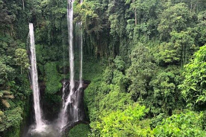
You push through a curtain of jungle and the air changes—cooler, scent heavy with wet earth and moss. Light slices through the canopy in thin beams and, somewhere below, water thunders. That first glimpse of Sekumpul is not cinematic so much as physically persuasive: multiple ribbons of white falling from a dark green wall into a basin framed by ferns and volcanic rock. For a long second you only listen. The falls demand your attention and, in return, give a clear, immediate kind of calm.
This day-trip stitches together two different moods of northern Bali. Sekumpul is raw and theatrical—multiple high drops fed by tributaries of the Serewe River—while nearby Banyumala is quieter, intimate: a multi-tiered cascade that feeds into emerald pools shallow enough to wade into on a hot day. Between them, the trek paths and the river crossings map a landscape shaped by volcanic uplift and centuries of traditional Balinese agriculture. The trail is a reminder that Bali isn’t all beaches and temples; up here the island shows itself as an island of rivers and cliffs, where monsoon-fed catchments cut steeply through the uplands.
Geologically, these falls are the product of Bali’s volcanic bones. Lava flows and subsequent erosion created the cliffs and ravines, and persistent rainfall carved channels that now tumble as waterfalls. Culturally, the region sits in Buleleng regency, where villages like Munduk and Sawan have woven rice terraces and clove and coffee gardens into the hillsides for generations. Local guides who lead the trek are often from nearby villages; on many tours, modest entrance or guide fees go directly to the community, supporting maintenance of trails and local incomes.
The approach to each waterfall tests your attention more than your ego. Sekumpul’s main viewpoint is reached via a roughly 3 km descent from the parking area with about 200–350 meters of elevation change depending on your route; expect uneven stone steps, muddy switchbacks and at least two shallow river crossings that require sure-footedness. Banyumala’s trail is shorter—roughly 1 km with a steep stair descent of 150–200 steps—but it can be slippery and narrow where the path squeezes between roots and rocks. You’ll move from dried leaves to riverine greenery and feel the temperature drop with each step toward the pools.
Timing matters: aim for a morning start. The light hits Sekumpul best between 8–10 a.m., and the trails are quieter before day-trippers arrive. Depending on your pickup point—many tours depart from Ubud or the central-south—this is an all-day outing; the Viator-style itinerary runs about eight hours including transport. Water levels can change a lot with recent rains, so the falls look their most dramatic after some wet weather, but swollen currents make river crossings more hazardous.
Practicalities—what you’ll actually do and need—are straightforward. Expect an active day: hiking on uneven terrain for 2–4 hours total, crossing shallow streams, and balancing on rocks if you go down to the pools. Good trekking sandals or trail shoes with grip help; poles are useful for descent/ascent if you prefer extra balance. Bring a waterproof bag for electronics and a change of clothes if you want to wade. Locally run warungs near trailheads sell cold drink and simple snacks but carry cash for small purchases and guide tips.
Respect for place matters here. The falls are accessed through village land and jungle paths that are part of living ecosystems. Follow your guide’s directions, keep to established paths, and pack out any trash. If you want to swim, check current conditions—underwater rocks are plentiful and currents can be stronger than they look.
For photographers and slow observers, both falls reward a patient eye. Sekumpul’s multiple streams create layered compositions—foreground ferns, middle-ground river, and curtains of water behind. Banyumala favors wide-angle shots with foreground rocks or bathing visitors for scale. Early light and mist create mood; midday can flatten shadows but deepen colors of moss and water.
Who should go? Casual hikers with good footwear and a sense of adventure will enjoy the trails; families with older kids can handle the paths if you take it slow. If you have mobility limitations or fear of steep descents, the trip may prove difficult—the stair sections and river crossings require balance. Guides often adapt routes for different groups, so ask about alternatives before booking.
Logistically, the trip is commonly run as a full-day private or small-group tour from Ubud, Lovina or Munduk. Pickup and transport are usually included; an experienced local guide will navigate the trails, arrange entrance fees, and point you toward the best viewpoints. For an economical visit, combine both falls into one day rather than trying to split them—travel time in Bali can be deceptively long on narrow, winding roads.
At the end of the day you’ll find yourself rinsing off in a roadside spring or sipping a Balinese coffee while the van hums toward town. The waterfalls leave an uncomplicated impression: places of moving water that pull attention out of calendar time and into the present. They are sporty without being extreme, verdant without being domesticated—an excellent day’s work for a traveler who wants to chase scenery, feel small under a cliff face, and return with a better sense of Bali’s inland heart.
Why book it? If a single day trip can reframe your idea of Bali from temple-and-beach postcard to island of rivers, cliffs and cooperative village life, this one does it cleanly. You’ll hike, get wet, and come away with images—literal and otherwise—of a wilder Bali.
Trail wisdom
Small choices, better day.
Start early
Morning light and lighter crowds make for better views and safer trail conditions.
Wear grippy footwear
Expect slippery rocks, muddy sections, and river crossings—trail shoes or strong sandals help.
Waterproof your kit
A dry bag or zip-locks protect phones and cameras from spray and sudden rain.
Carry local cash
Bring small bills for entrance fees, warung snacks, and tipping your guide.
Local knowledge
Read the place, not just the route.
Watch for native species including Long-tailed macaques in surrounding forests (keep distance), Kingfishers and sunbirds around streams and pools.
Keep an eye out for wildlife during the transition between areas and habitats. Respect distance guidelines.
Trails pass through community-managed land—support local guides, stay on paths, and pack out waste to minimize impact.
Follow the guide's instructions on size limits, ethical handling, and leave-no-trace practices.
Coffee plantation stops near Munduk for fresh Arabica and local processing demonstrations. Small village warungs serving grilled fish or ayam betutu near trailheads for a post-hike meal
Locally recommended viewpoints and quiet spots known best to local operators.
The waterfalls flow through landscapes shaped by Bali's volcanic activity and centuries of terraced agriculture; nearby villages preserved traditional farming and craft practices.
Maritime roots and regional tradition shape the waterways and working coasts.
Seasonal guide
Four versions of the same landscape.
Spring
Best forLush foliage · Fewer tourists
ChallengesIntermittent showers · Muddy trails
Spring (March–May) sees the landscape freshening after rains—trails can be muddy but the waterfalls are robust.
Summer
Best forDryer trails · Clearer travel conditions
ChallengesHotter transport days · Stronger sun mid-day
Summer (June–August) is drier and busiest; mornings are best to avoid heat and crowds.
Fall
Best forDramatic water flow after storms · Rich greens
ChallengesUnpredictable rain · Slippery descent sections
Fall (September–November) can deliver powerful flows following seasonal storms—respect river conditions.
Winter
Best forLush rainforest atmosphere · Lower sunlight angles
ChallengesHeaviest rains (Nov–Mar) · Higher currents and access issues
Winter in Bali corresponds to the wet season—spectacular waterfalls but more hazardous crossings and access interruptions.
Operator details
What the booking data adds.
Included
- ✓Bottled water
- ✓Air-conditioned vehicle
Not included
- —Personal expenses
- —All Fees and Taxes
Good to know
- ✓Infants and small children can ride in a pram or stroller
- ✓Public transportation options are available nearby
- ✓Infants are required to sit on an adult’s lap
- ✓Not recommended for travelers with poor cardiovascular health
- ✓Suitable for all physical fitness levels
Pack with intention
What to bring.
Good to know
Common questions.
Expect uneven terrain, a 200–350 meter descent/ascent depending on the route, and several river crossings; moderate fitness and sure-footedness are required.
Plan the edges
The details that make the day easier.
Sekumpul is actually a cluster of falls fed by tributaries of the Serewe River—its multiple streams and dramatic cliff face are often cited as some of Bali’s most striking inland cascades.
After the hike, stop in Munduk for kopi luwak or local Arabica at a plantation café and try ikan bakar (grilled fish) or sate lilit at a village warung; small guesthouses and family-run restaurants make for quiet post-trek meals and chance encounters with local farming life.
- Closest airport
- Ngurah Rai (Denpasar) — ~2.5–3 hours drive; Common trailhead: near Munduk
- Sawan villages; Driving distance from Ubud
- ~2.5–3 hours; Cell service: patchy on the trail, better near villages; Permits: small local entrance or guide fee usually applies (included on organized tours).
These falls sit in community-managed land—support local guides and warungs, stay on established trails, and carry out any trash; avoid using soaps in natural pools.
Explore by topic
Follow the threads.
Keep exploring
Make the story part of the trip.
In four hours you can move from shaded canyon ferns to wind-scoured coastal ridgelines, guided by someone who knows where the light—and the hidden views—live. This private half-day hike on the Monterey Peninsula or Big Sur is compact, curated, and perfect for travelers who want depth without a multiday commitment.
 Related story
Beneath a sky of shifting light, Skaftafell’s ice reads like a map of time. This three-hour guided glacier hike mixes technical instruction with geology and culture: compact, safe, and unforgettable.
 Related story
Lose the city for a few hours without leaving it: this 5-mile, 900-foot-gain Forest Park loop threads old-growth pockets, city viewpoints, and cultural landmarks for a compact taste of Portland’s wild side. Expect moss, roots, and stories.