
What the day feels like
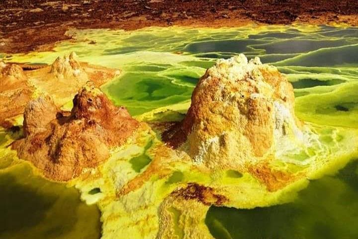
You break the horizon at first light and the land answers like a furnace. The road from Mekele winds through scrub and basalt, then it simply ends—there is no more road to the Danakil Depression, only salt-carved tracks and a horizon that looks as if the earth has been peeled back. On a three-day loop you trade asphalt for four-wheel-drive dust, swap hotel beds for flat tents and the predictable for a place where the ground steams and color behaves badly. At Dallol, fluorescent pools bubble like a painter’s nightmare; at Erta Ale, a ribbon of lava churns in a stubbornly alive cauldron. It’s not pretty in the gentle sense—it's violent, raw and, for those who arrive prepared, unforgettable.
The Danakil is the northernmost part of the Afar Depression, where three tectonic plates—the African, Somali and Arabian—pull apart and reveal the planet’s down-underworkings. Geology here is immediate: salt plains like polished mirrors, sulfur terraces that look almost artificial, and volcanic cones that tell stories in black and orange. The region’s heat is literal too—average daytime temperatures in the lowlands climb well into the 40s Celsius in summer, making travel an exercise in timing and respect. People live here as well: the Afar people have carved a life from salt caravans and pastoralism, and their knowledge—when to travel, where to pitch camp, how to read the shifting winds—is the difference between a safe expedition and a misadventure.
This three-day itinerary is compact but purposeful. Day one is transit and acclimatization: a long, dusty drive from Mekele to the salt flats, where you watch light split off the white ground as the sun drops. The second day moves into Dallol—sulfur springs, candy-colored mineral chimneys and pools that steam with acidic breath—and the close-up surrealism of the depression’s hydrothermal activity. The payoff comes on the third day with Erta Ale, one of the few persistent lava lakes on Earth. It’s a night approach: you hike across black volcanic rubble under a dome of stars and stand at the rim while the lake boils and spits, a quiet, terrifying heartbeat below.
Culturally, the Danakil is a place of contrasts. The Afar are famously independent; they trade salt slabs on camelback, a practice that predates automobiles. Camps run by local operators often feel like an interplay of hospitality and practical logistics: hot tea on arrival, a thin mat in a canvas tent, and guides who rarely waste words but always answer when it matters. The area’s modern access is young—roads are rough, permissions are required, and the infrastructure is tailored around small groups and patient itineraries.
For adventurers this tour is honest: it asks for heat tolerance, patience for long drives, and an appetite for uncanny landscapes more than technical mountaineering skills. Safety is logistical—lowering your risk means hiring experienced Afar guides, respecting the environment, staying hydrated, and carrying the right kit. A guide knows when the wind will change the steam patterns at Dallol, or how to approach the crater rim after dark at Erta Ale without kicking loose a rock. On a practical level, the trip generally includes a 4x4 support vehicle, local permits, camp meals, and an experienced crew; travel agencies often stage the departure from Mekele.
Why go? Because few places on Earth let you witness geological processes with such cinematic directness. The color at Dallol is impossible to Photoshop—acid pools in neon green and yellow, iron oxides blistered into orange terraces—and Erta Ale’s lava lake is a lesson in planetary restlessness. For photographers, scientists and anyone with a small hunger for discomfort and big horizons, it’s worth the effort. For less confident travelers, a shorter day trip into salt flats still offers a taste: wide light, the electric hush of an expanse without trees, and the humbling scale of land that refuses to behave like the rest of the planet.
If you go, travel with humility. The Danakil does not negotiate. Respect local customs—ask permission before photographing people, accept the necessity of permits and guided travel, and be ready to adapt plans to weather and safety. Consider the timing: early mornings and late afternoons are where temperatures are manageable and the light is spectacular. Night approaches to Erta Ale maximize the drama of molten rock but demand steady footing and a headlamp; your guide’s instructions are authoritative, not optional.
Practical details: this tour runs roughly 72 hours and typically starts in Mekele. Costs start around USD 560, covering transport, local guides, many meals and camping; confirm precisely what’s included before you buy. Bring multiple liters of water daily, high-SPF sun protection, sturdy boots for volcanic scree and breathable layers for sudden drops in temperature after sunset. Know that cell service is intermittent at best; this trip is part spectacle, part full-stop unplug. But when you stand at the rim of a lava lake and the world seems to contract to the glow and the hiss of molten earth, you’ll be reminded why some journeys are worth the friction.
The Danakil is not for everyone—and it’s better for that. It rewards curiosity, practical preparation and a willingness to trade comfort for something that will change how you understand the planet. If you leave with dust in your hair and a photograph that won’t do the scene justice, you’ve done it right.
Trail wisdom
Small choices, better day.
Hydrate Before You Need It
Drink regularly—aim for 3–4 liters per day in hot months—because heat-related symptoms can come on quickly in the depression.
Go With Local Guides
Hire experienced Afar guides to handle permits, navigation and safety on volcanic terrain and during night approaches to Erta Ale.
Protect Against Acidic Steam
Avoid getting too close to steaming pools at Dallol; wear a bandana or buff to filter irritating fumes and use eye protection if wind changes suddenly.
Footwear for Black Rock
Wear sturdy boots with good ankle support for volcanic scree around Erta Ale and for trekking between camps.
Local knowledge
Read the place, not just the route.
Watch for native species including Dromedary camels (domestic caravans), Desert foxes and occasional birdlife such as larks.
Keep an eye out for wildlife during the transition between areas and habitats. Respect distance guidelines.
The region is ecologically fragile—avoid trampling delicate crusts at Dallol, pack out all waste, and travel only with licensed operators to reduce impact.
Follow the guide's instructions on size limits, ethical handling, and leave-no-trace practices.
Watch sunrise over the salt flats for incredible, changing reflections. Afar salt caravan tracks—ask your guide to point out old caravan routes and salt-cut marks
Locally recommended viewpoints and quiet spots known best to local operators.
The Danakil salt trade has been practiced for centuries by the Afar people, who still transport salt slabs by camel between mines and markets.
Maritime roots and regional tradition shape the waterways and working coasts.
Seasonal guide
Four versions of the same landscape.
Spring
Best forCooler daytime temperatures · Clear skies for photography
ChallengesResidual seasonal heat · Dusty winds
Spring offers milder heat than summer and sharp light for color at Dallol, though winds and dust can still be an issue.
Summer
Best forMinimal rain interference · Most tour availability
ChallengesExtreme daytime heat · High dehydration risk
Summer is the hottest time—plan activities early/late and prioritize hydration and shade where possible.
Fall
Best forComfortable evenings · Good volcanic viewing conditions
ChallengesUnpredictable transport due to rains elsewhere · Limited infrastructure
Fall balances heat and comfort; evenings cool nicely and volcanic features remain dramatic.
Winter
Best forCooler days for trekking · Clear night skies for stargazing
ChallengesCold nights in camps · Shorter daylight hours
Winter has the most comfortable daytime temperatures but expect cold nights—bring warm layers for camp.
Operator details
What the booking data adds.
Included
- ✓Entrance Fees
- ✓Professional local guide and scout
- ✓Lunch
- ✓Dinner
- ✓Breakfast
- ✓Accommodation or camping
- ✓Transportation 4x4
Not included
- —All alcoholic drinks
- —Tips
- —Any flight
Good to know
- ✓Public transportation options are available nearby
- ✓Not recommended for travelers with spinal injuries
- ✓Not recommended for pregnant travelers
- ✓Not recommended for travelers with poor cardiovascular health
- ✓Travelers should have at least a moderate level of physical fitness
Pack with intention
What to bring.
Good to know
Common questions.
Yes—most operators include necessary permits and security arrangements; independent travel is discouraged due to local regulations and safety.
Plan the edges
The details that make the day easier.
Dallol holds one of the lowest average ground elevations on Earth—around 125 meters below sea level—and is also one of the hottest places year-round.
After a day on the salt flats, return to Mekele for injera and stews; try local coffee rituals and look for small restaurants serving grilled meat and pasta—Afar camps also serve strong sweet tea and communal meals with storytelling.
- trailhead
- Mekele Airport (MQX)
- trip departs from Mekele; Driving distance
- ~6–10 hours total on rough roads depending on itinerary; Cell service: intermittent to none in the depression; Permits: Required—usually arranged by operator
The Danakil’s fragile mineralscapes and limited water resources mean travelers should stick to established tracks, carry out all trash, and support local guides and communities to keep tourism benefits local.
Explore by topic
Follow the threads.
Keep exploring
Make the story part of the trip.
In four hours you can move from shaded canyon ferns to wind-scoured coastal ridgelines, guided by someone who knows where the light—and the hidden views—live. This private half-day hike on the Monterey Peninsula or Big Sur is compact, curated, and perfect for travelers who want depth without a multiday commitment.
 Related story
Beneath a sky of shifting light, Skaftafell’s ice reads like a map of time. This three-hour guided glacier hike mixes technical instruction with geology and culture: compact, safe, and unforgettable.
 Related story
Lose the city for a few hours without leaving it: this 5-mile, 900-foot-gain Forest Park loop threads old-growth pockets, city viewpoints, and cultural landmarks for a compact taste of Portland’s wild side. Expect moss, roots, and stories.