
What the day feels like
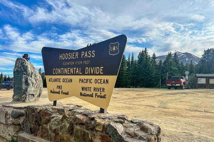
By midmorning the car eases onto a high shoulder of the Continental Divide and the world opens. Aspen trunks flash silver, their leaves thin to a tremulous gold, and a wind that has been shaping these mountains for millennia tugs at the jacket on your back. At 11,542 feet, Hoosier Pass is a blunt punctuation mark on the climb from the Front Range to the high Rockies—an abrupt, clean line between forested valleys and the bald, lichen-scabbed ridgelines beyond. The private Colorado tour that cuts from Colorado Springs to Breckenridge via this pass is, at heart, a day of thresholds: altitude, history, and landscape shifting with every mile.
Drive with a guide and it becomes more than scenery. You roll through towns that thrived on the 19th-century mineral boom—Leadville still keeps the architecture and edge of that era, its streets slanted toward an old, practical grandeur—and the conversation slides between the pragmatic (watch for patches of black ice in shoulder seasons) and the immediately poetic (how the divide seems to split weather like a tailor). Breckenridge itself is a compressed encyclopedia of a Colorado mountain town: Victorian storefronts, ski-lift silhouettes on the ridgeline, restaurants that lean hard on local game and microbrews. In summer the slopes are a broad, floral carpet; in winter they smell sharp with cold and lift grease.
Geologically, the route is a cross-section of the Rockies’ story. You climb on uplifted bedrock and ancient volcanic scars; valleys were carved by glaciers and now collect tarns and meadows that flush neon-green after a storm. These high basins—tundra above the tree line—host a fragile ecology that has taken thousands of years to assemble, a living mosaic of dwarf willows, sedges, and wildflowers. It’s not just pretty; it is a working landscape shaped by past miners, road-builders, and the rhythm of seasonal snowpack. Hoosier Pass itself sits on the Continental Divide where snowmelt decides whether it will eventually touch the Atlantic or the Pacific.
There’s cultural texture here, too. Leadville’s story—gold, then silver, then the endurance of a mining town—echoes in local museums and the slate-gray facades of its former saloons. Breckenridge has embraced its mining past while evolving into a global ski and summer-recreation hub; the town is adept at welcoming day-trippers who want both a short hike and a long lunch. In town, breweries like Breckenridge Brewery and family-run bakeries coexist with outfitters who will kit you for a trail run or a backcountry gamble.
Practically, this is a doable day for most travelers who can handle thin air. The tour runs about 6–8 hours and is a private, guided transfer with stops that let you step into the landscape—walk a short alpine trail, look down into Leadville’s basin, or take in the view from Sapphire Point over Dillon Reservoir. It’s paced to show off the best windows: morning light on the eastern slopes, crisp air at Hoosier Pass when the sky is clearest, and a leisurely arrival in Breckenridge where you have time to wander and eat before returning.
Altitude is the main logistic story. Expect subtle effects—shortness of breath on even gentle uphill walks, headaches if you’re dehydrated—and plan accordingly. Hydrate, sleep well the night before, and keep exertion light in the first hours. Dress in layers: the temperature can swing 30 degrees between town and pass; a wind can make a sunny day feel austere. If you’re booking winter travel, be aware that the pass is high and conditions change fast—snow chains or a driver accustomed to winter mountain roads are non-negotiable.
If you’re thinking like a photographer, frame for scale: people and pines in the foreground give context to the sweep of the divide. Early- and late-day light is dramatic; midday is clean but harsher. Bring a wide-angle lens for ridgelines and a midtele for wildlife—marmots and bighorn sheep often pick sunlit ledges. Respect the fragile tundra when you step out for a shot: it recovers slowly from footprints.
A private tour at the $800 starting price makes sense if you want a tailored day—pick your stops, get local lore, and have someone else do the driving on narrow, high roads. The itinerary is flexible: add a museum stop in Leadville, a short hike on a maintained trail near Breckenridge, or a coffee and pastry break in town. For a single day that stitches together Colorado geography, mining history, and mountain-town culture in a way that’s both accessible and elevating, this route is a tidy, spectacular package.
Practical takeaways: hydrate early, dress in layers, keep your camera handy, and leave time in Breckenridge for a meal and a stroll on Main Street. On the Continental Divide, the air is thin and the views are wide; on this tour, you get both with a local who knows where to pull over. It’s a single-day trip that manages to feel like a short, sharp expedition and a civilized escape all at once.
Trail wisdom
Small choices, better day.
Hydrate Before You Go
Drink water in the 24 hours before the tour and carry a liter per person—altitude dehydrates faster than you expect.
Layer Strategically
Temperatures can swing dramatically; pack a windproof shell plus a warm mid-layer.
Short Walks Only at Altitude
Keep hikes short and pace steady—even small climbs feel harder above 9,000 feet.
Sun Protection Is Crucial
UV is stronger at high elevation—wear sunscreen, sunglasses, and a brimmed hat.
Local knowledge
Read the place, not just the route.
Watch for native species including Marmot, Elk.
Keep an eye out for wildlife during the transition between areas and habitats. Respect distance guidelines.
The alpine tundra is fragile—stick to established overlooks and trails, pack out all trash, and avoid trampling vegetation.
Follow the guide's instructions on size limits, ethical handling, and leave-no-trace practices.
Sapphire Point Overlook on the Dillon Reservoir for dramatic ridgeline photos. Healy House Museum (Leadville) for mining-era artifacts and local history
Locally recommended viewpoints and quiet spots known best to local operators.
Leadville boomed during the silver rush of the late 19th century; traces of mining and Victorian architecture remain visible in town.
Maritime roots and regional tradition shape the waterways and working coasts.
Seasonal guide
Four versions of the same landscape.
Spring
Best forMelting snows and waterfalls · Early-season quiet · Wildflower beginnings
ChallengesUnpredictable weather · Snow patches at higher elevations
Spring brings melting snow and early wildflowers lower down, but expect variable conditions on Hoosier Pass; roads can still have snow.
Summer
Best forWarm days and long light · Alpine wildflowers · Full access to roads
ChallengesAfternoon thunderstorms · Crowds on sunny weekends
Summer is peak access—clear passes and lush meadows—but plan drives to avoid afternoon storms and reserve any dining or tours.
Fall
Best forAspen color displays · Crisp clear air · Fewer tourists
ChallengesEarly snow at altitude · Shorter daylight hours
Fall is dramatic for foliage and visibility; bring warm layers and check road conditions for early snow.
Winter
Best forSki-town atmosphere · Snow-covered passes · Photographic high-contrast scenes
ChallengesSnow/ice on roads · Chain requirements and closures possible
Winter offers stark, beautiful landscapes but requires an experienced driver and winter vehicle preparations.
Operator details
What the booking data adds.
Included
- ✓Private transportation
- ✓Soda/Pop
- ✓WiFi on board
- ✓Bottled water
- ✓Snacks
- ✓Air-conditioned vehicle
- ✓Picnic style lunch provided
Good to know
- ✓Infants and small children can ride in a pram or stroller
- ✓Not recommended for travelers with poor cardiovascular health
- ✓Suitable for all physical fitness levels
- ✓Please note: the two-person third row seat has less leg room and best suited for children.
Pack with intention
What to bring.
Good to know
Common questions.
The tour typically departs from Colorado Springs (exact pickup location is confirmed at booking) and returns there after visiting Hoosier Pass, Leadville, and Breckenridge.
Plan the edges
The details that make the day easier.
Hoosier Pass sits at 11,542 feet on the Continental Divide, and Leadville is the highest incorporated city in North America at about 10,152 feet.
After a day on the pass, head to Breckenridge’s Main Street for wood-fired pizza or bison burgers, then try a local brew at Breckenridge Brewery; in Leadville, find a miner-era saloon or the Healy House Museum for context.
- Closest major airport
- Denver International Airport (approx 2–2.5 hours to Breckenridge); Driving distance from Colorado Springs: ~120 miles (~2.5–3 hours); Cell service: intermittent on Hoosier Pass; Permits
- passes
- none required for standard stops—check seasonal road advisories.
This route crosses fragile alpine environments—stay on designated pullouts and trails, pack out all trash, and avoid disturbing wildlife to reduce your impact.
Explore by topic
Follow the threads.
Keep exploring
Make the story part of the trip.
Set out from Bass Harbor for a private, customizable day on Blue Hill Bay — lighthouses, puffins, seals, and the chance to feel Acadia from the water. Small groups, local captains, unforgettable views.
In four hours you can move from shaded canyon ferns to wind-scoured coastal ridgelines, guided by someone who knows where the light—and the hidden views—live. This private half-day hike on the Monterey Peninsula or Big Sur is compact, curated, and perfect for travelers who want depth without a multiday commitment.
 Related story
Beneath a sky of shifting light, Skaftafell’s ice reads like a map of time. This three-hour guided glacier hike mixes technical instruction with geology and culture: compact, safe, and unforgettable.