Scenic Canyon and Waterfall at Rio de Flag, Arizona
Scenic Canyon and Waterfall at Rio de Flag, Arizona
Category
Hiking
Typical Duration
2-4 hours
Difficulty
Moderate
Photo Gallery
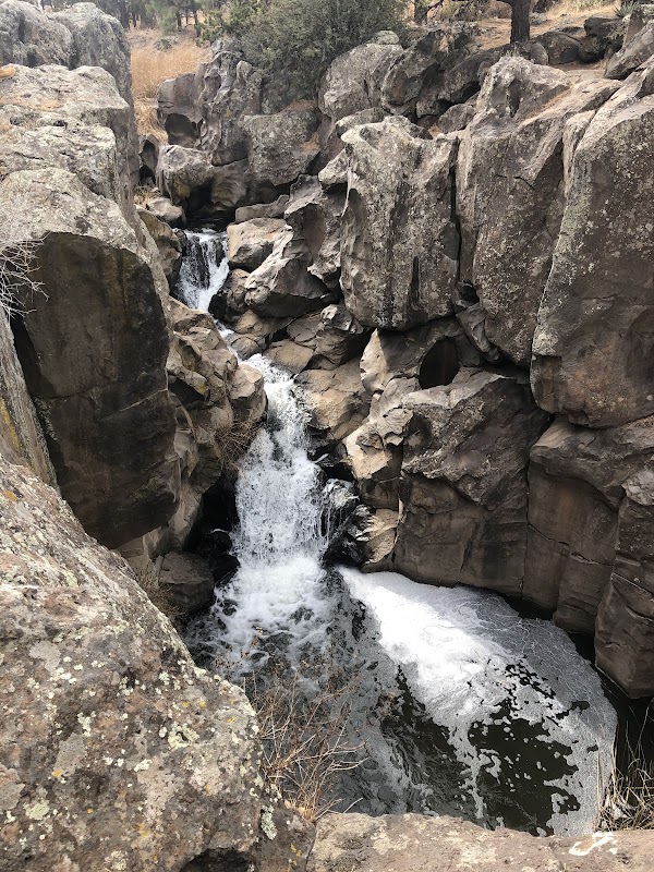
Scenic Canyon and Waterfall at Rio de Flag, Arizona - Rio de Flag
Scenic Canyon and Waterfall at Rio de Flag, Arizona - Rio de Flag
Scenic Canyon and Waterfall at Rio de Flag, Arizona - Rio de Flag
About This Landmark
Natural Gem Rio de Flag Near Flagstaff, Arizona
Rio de Flag is a captivating natural landmark located near Flagstaff in northern Arizona, distinguished by its rugged canyon and flowing water features carved through volcanic rock formations. This spot stands out due to the dramatic contrast between the dark volcanic stone and the frothy white waters rushing through narrow channels, creating a charming, intimate waterfall experience unlike many others in the region.
The canyon walls exhibit weathered basalt rock, a signature of the area’s volcanic activity millions of years ago, which adds geological intrigue to the scene. Amidst the arid surroundings typical of northern Arizona, the flowing water offers a refreshing visual and auditory respite. Visitors can appreciate the secluded feel of the gorge, which is somewhat hidden yet accessible from Flagstaff’s urban edge.
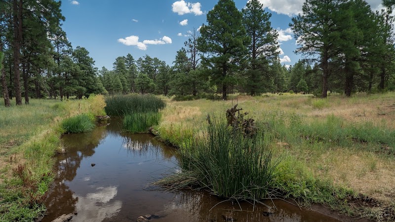
Rio de Flag’s watercourse is seasonal and can vary significantly with rainfall, contributing to the dynamic nature of this landmark. The surrounding landscape includes dry grass, scattered shrubs, and juniper trees, reflecting the high-desert ecosystem. This location offers a peaceful setting for witnessing natural erosive forces shaping the rocks and water.
While not a major tourist draw compared to other Arizona natural wonders, Rio de Flag holds local significance and offers a unique glimpse into the region’s volcanic past and hydrological patterns. Outdoor lovers who appreciate geological formations and quiet natural spots will find this creek and its rocky cascades compelling.
Whether visiting for scientific interest or a calming nature stroll, Rio de Flag presents an understated but rewarding destination near Flagstaff’s varied outdoor attractions.
Adventure Guide To Rio de Flag
1. Hiking Along Rio de Flag Canyon
- What makes it special: The trail follows the creek through a narrow basalt-walled canyon, providing close-up views of the unique volcanic rock formations and a small but scenic waterfall.
- Key features: Rocky terrain, shaded sections, creek crossings.
- Local insights: Best after spring rains when water flows are stronger.
- Visitor tips: Wear sturdy shoes; bring water and sun protection. Avoid hiking during extreme heat.
2. Geological Photo Walk
- What makes it special: Capture volcanic basalt features alongside water textures and canyon colors.
- Key features: Varied rock surfaces, flickering water reflections.
- Local insights: Early morning or late afternoon provides the best lighting.
- Visitor tips: Use a zoom lens for details; watch footing on rocks.
3. Creekside Picnic and Nature Observation
- What makes it special: Quiet spot to enjoy nature sounds and watch local wildlife like birds and small mammals.
- Key features: Secluded areas with natural seating on rock ledges.
- Local insights: Pack out all trash; respect the habitat.
- Visitor tips: Bring insect repellent and a lightweight picnic.
Getting There: Rio de Flag is about 5 miles northeast of downtown Flagstaff. From Flagstaff, take Route 89 north and then local roads toward Wupatki National Monument, signs will guide to nearby trailheads. It’s approximately a 10-15 minute drive.
Best Time to Visit: Spring to early summer offers flowing water and moderate temperatures.
What to Bring: Comfortable hiking shoes, water bottle, sunscreen, camera, and a hat.
Driving Directions: From Flagstaff city center, head north on Route 89 for 4 miles, then turn east on Rio de Flag Roads near local signs to trail access points.
Ratings
Overall
Photography
Featured Activities
Primary Activity
Hiking
Also Great For
Essential Information
Nearby City
Flagstaff, Arizona
Protected Areas
Experience Level
Experience Needed: This natural landmark is recommended for those with some outdoor experience. Good for regular hikers.