
Paricutin Volcano National Park Adventures
Paricutin Volcano National Park features a unique volcanic landscape centered around the youngest volcano in the Western Hemisphere, offering visitors a rare chance to explore dramatic lava fields, ash plains, and volcanic craters through hiking and cultural experiences.
About Paricutin Volcano National Park
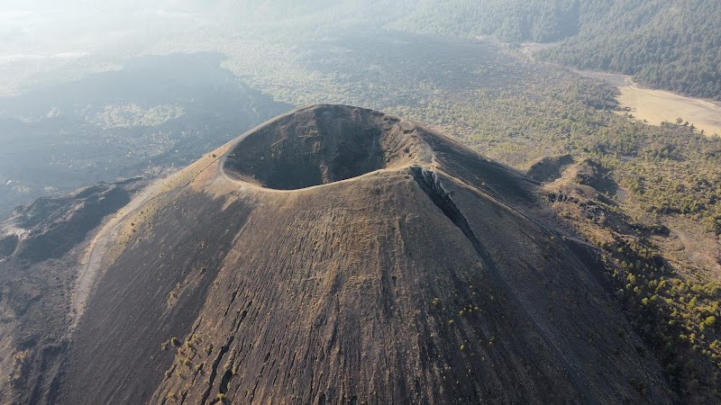
Paricutin Volcano National Park is located in the state of Michoacán, Mexico, and is dedicated to preserving the site of Paricutin Volcano, which erupted unexpectedly in a farmer’s cornfield in 1943 and rapidly grew to over 1,300 feet above the surrounding plain. The park covers the volcanic landscape created during this eruption, which lasted for nine years, making it one of the most significant geological events of the 20th century. Visitors experience an extraordinary environment dominated by hardened lava flows, volcanic ash deposits, and rugged cinder cones. The ecology is adapted to the volcanic soil, with pioneering vegetation such as shrubs and grasses beginning to reclaim the land. The park offers several trails that allow hikers to reach the volcano's crater rim, providing panoramic views of the surrounding Purépecha Highlands. Cultural heritage is also prominent, as the eruption forced the evacuation of local villages, and many Purépecha communities live nearby, preserving traditional ways of life. Outdoor enthusiasts are attracted to the moderate hikes to the crater, guided tours explaining volcanic activity, and opportunities for photography. Paricutin Volcano National Park serves as a natural laboratory for studying volcanology and ecological succession, attracting scientists and visitors alike. Its relative remoteness and fascinating geological story make it a distinctive destination within Mexico’s protected areas.
Highlights
Summit of Paricutin Volcano with views across lava fields and Michoacán plains
Volcanic caves formed by hardened lava flows for exploration
Interpretive exhibits about the 1943 eruption and local Purépecha culture
Remote trails through recovering volcanic ecosystems with endemic plants
Notable Natural Features
Paricutin Volcano Crater
The prominent cinder cone formed during the 1943 eruption, rising 1,353 feet from the valley floor, accessible by a steep hiking trail.
Lava Fields and Caves
Extensive areas of hardened basaltic lava flows with lava tubes and small caves formed during the volcanic activity.
Purépecha Villages
Nearby indigenous communities that relocated after the eruption and maintain rich cultural traditions connected to the land.